Jamalabad
.jpg)
Jamalabad Fort is an old hilltop fortification in Killoor road, Belthangady, Dakshina Kannada District, Karnataka, India. It is located in the Kudremukh range of hills,[1] 8 km north of Beltangady town and 65 km from the city of Mangalore. It is also referred locally as "Jamalagadda" or "Gadaikallu".
History
The fort was built by Tipu Sultan in 1794[1] and named after his mother, Jamalabee. He decided to build a fort there, as he was impressed by the massive granitic rock which was suitable for the construction of a strong fort.[2] The fort was built over the ruins of an older structure.
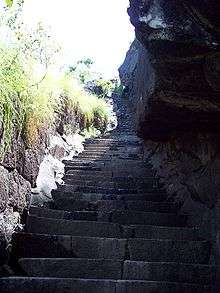
The fort is accessible via a narrow path, with around 1876 steps to the fort that are cut out of the granite hill and lead all the way to the top.
Inside the fort, there is a tank to store rainwater. Remains of a single cannon lie at the top. Nothing much of the fortifications remain but hints of the fort wall with parapets are visible. The fort was captured by the British in 1799 during the 4th Mysore war. Legend has it that those out of favour with Tipu were hurled down the edge to their death.
Trekking
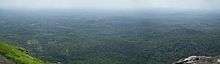
Jamalabad is a trekking destination, with the climb up to the fort being classified as 'medium difficulty level' and the top of the structure offering good views of the surrounding landscape and the Kudremukh range.
At the base of the hill is a forest check post where visitors have to pay a nominal entry fee. Visitors should carry food and plenty of water since there is no potable fresh water available on top. The nearest town with any communication and medical facilities is Beltangady.
Entry to the fort is open between 6 am and 4 pm and overnight stay at the fort is prohibited. This hillock fort has one room at the top.
There is also an unmanned microwave repeater station on top of the hill.
See also
Citations
| Wikimedia Commons has media related to Jamalabad. |
- 1 2 Ranade, Prabha Shastri (2009). "Chapter 5: Tourism Development". Infrastructure Development and Its Environmental Impact: Study of Konkan Railway. New Delhi: Concept Publishing Company. p. 162. ISBN 978-81-8069-450-9.
- ↑ Bhat, N. Shyam (1998). South Kanara, 1799–1860: a study in colonial administration and regional response. Mittal Publications. p. 81. Retrieved 05-12-2012. Check date values in:
|accessdate=(help)
Coordinates: 13°1′37.38″N 75°17′41.02″E / 13.0270500°N 75.2947278°E