Jacaguas River
| Jacaguas River | |
|---|---|
| Country | Puerto Rico |
| Physical characteristics | |
| Main source |
Villalba 2,099 feet (640 m) |
| River mouth |
Caribbean Sea 0 feet (0 m) |
| Length | 24.68 miles (39.72 km)[1] |
| Discharge |
|
| Basin features | |
| Progression | Juana Diaz, Ponce |
| River system | Jacaguas River |
| Basin size | 59.85 sq mi (155.0 km2)[3] |
| Tributaries |
|
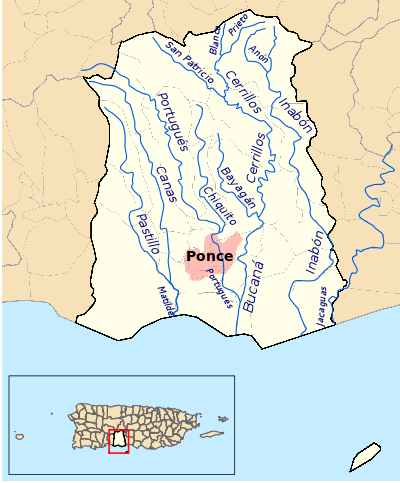
Jacaguas River (Spanish: Río Jacaguas) is a river shared between the municipalities of Ponce and Juana Diaz. It flows from north to south, draining into the Caribbean Sea east of the city of Ponce. One of the 14 rivers in the municipality of Ponce, it is also the longest, at 39.72 kilometers (24.68 mi). The river has a discharge of 37,000 ft3/second, making it the most affluent river in Ponce as well.[4]
Origin and course
Jacaguas has its origin in the municipality of Villalba, Puerto Rico, in the boundary between barrio Vacas and barrio Hato Puerco Arriba,[5] at an altitude of approximately 2,099 feet (640 m) above sea level. It crosses the municipalities of Villalba and Juana Díaz, forming the Guayabal Lake, before approaching the municipality of Ponce where it becomes the boundary between Ponce and Juana Diaz. From there it empties into the Caribbean Sea.
See also
Coordinates: 17°58′26″N 66°32′22″W / 17.9738553°N 66.5393380°W[6]
References
- ↑ Los Rios. Archived April 1, 2012, at the Wayback Machine. Hojas de Nuestro Ambiente. February 2007: P013. Page 3. Puerto Rico Department of Natural and Environmental Resources. Retrieved 30 October 2011.
- ↑ Ferdinand Quiñones and Karl G. Johnson. The Floods of May 17–18, 1985 and October 6–7, 1985 in Puerto Rico. U.S. Geological Survey. Open File Report 87-123. Prepared in Conjunction with the Puerto Rico Department of Natural Resources, Puerto Rico Environmental Quality Board, and the Puerto Rico Highway Authority. San Juan, Puerto Rico. 1987. Page 15.
- ↑ Los rios de Puerto Rico. MiTaino.com. 2009. Originally from the Puerto Rico Department of Natural and environmental Resources. Retrieved 7 December 2011.
- ↑ U.S. Geological Survey Geographic Names Information System: Río Jacaguas