Itter
| Itter | ||
|---|---|---|
 | ||
| ||
 Itter Location within Austria | ||
| Coordinates: 47°28′14″N 12°08′38″E / 47.47056°N 12.14389°ECoordinates: 47°28′14″N 12°08′38″E / 47.47056°N 12.14389°E | ||
| Country | Austria | |
| State | Tyrol | |
| District | Kitzbühel | |
| Government | ||
| • Mayor | Johann Gratt | |
| Area | ||
| • Total | 10.44 km2 (4.03 sq mi) | |
| Elevation | 703 m (2,306 ft) | |
| Population (1 January 2016)[1] | ||
| • Total | 1,162 | |
| • Density | 110/km2 (290/sq mi) | |
| Time zone | UTC+1 (CET) | |
| • Summer (DST) | UTC+2 (CEST) | |
| Postal code | 6305 | |
| Area code | 05335 | |
| Vehicle registration | KB | |
| Website | http://www.itter.tirol.gv.at | |

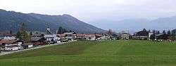
Itter is a municipality in the Kitzbühel District in the Austrian state of Tyrol located 18.60 km west of Kitzbühel, 5 km southeast of Wörgl, and 2.5 km north of Hopfgarten im Brixental. The village lies on a terrace above the Brixental valley and its main source of income is tourism.
Population
| Historical population | ||
|---|---|---|
| Year | Pop. | ±% |
| 1869 | 499 | — |
| 1880 | 479 | −4.0% |
| 1890 | 424 | −11.5% |
| 1900 | 434 | +2.4% |
| 1910 | 447 | +3.0% |
| 1923 | 444 | −0.7% |
| 1934 | 480 | +8.1% |
| 1939 | 489 | +1.9% |
| 1951 | 587 | +20.0% |
| 1961 | 646 | +10.1% |
| 1971 | 792 | +22.6% |
| 1981 | 910 | +14.9% |
| 1991 | 980 | +7.7% |
| 2001 | 1,060 | +8.2% |
| 2011 | 1,180 | +11.3% |
Sights
The small castle of the village, Itter Castle, was a prison for French high personalities during World War II. Two days before the war ended, a battle was fought there against the Waffen SS, the only occasion when American and German forces fought on the same side during the war.
References
External links
| Wikimedia Commons has media related to Itter. |
This article is issued from
Wikipedia.
The text is licensed under Creative Commons - Attribution - Sharealike.
Additional terms may apply for the media files.