Itaya River
| Itaya River | |
|---|---|
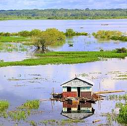 A view of the Itaya River from the city of Iquitos | |
| Other name(s) | Río Itaya |
| Country | Peru |
| City | Iquitos |
| Basin features | |
| River system | Amazon Basin |
The Itaya River is a tributary of the Amazon River via the Nanay River in northern Peru. The Itaya flows alongside the city of Iquitos and the district of Belén.
In Iquitos, a riverwalk and breakwater called Malecón Tarapacá overlooks the Itaya.[1] To the north of Malecón Tarapacá is Malecón Maldonado.[1]
The Itaya River is the namesake of the fan palm genus Itaya, which was first discovered on the river's bank.[2]
The 2012 floods of the Amazon, Itaya, and Nanay Rivers left approximately 80,000 people homeless.[3] In April 2015, 11 hours of steady rain swelled the Itaya again, causing the Iquitos–Nauta highway to collapse at four points: kilometres 22, 22.2, 23, and 26.[4]

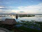
The Itaya River from vantages around Iquitos
See also
- Marañón River

References
- 1 2 "Malecón Tarapacá". MINCETUR. San Isidro: Ministry of Foreign Commerce and Tourism (Peru). Retrieved 2016-04-07.
- ↑ Piptocarpha (Compositae: Vernonieae). Flora Neotropica. New York: New York Botanical Garden Press. 2007. p. 51. ISBN 978-0-89327-482-5. OCLC 77504368.
- ↑ "Inundaciones afectan a unos 80 mil pobladores" [Flooding affects some 80,000 poor]. Perú.21 (in Spanish). 7 April 2012. Archived from the original on 2014-07-31. Retrieved 2016-04-07.
- ↑ "Loreto: Colapsó la carretera Iquitos-Nauta por crecida del río Itaya" [Loreto: Iquitos-Nauta highway collapsed by swelling of the Itaya River]. Perú.21 (in Spanish). 2 April 2015. Retrieved 2016-04-07.
External links
- Arellano Valdivia, Juan (4 April 2012). "La creciente del Amazonas y las inundaciones en Loreto" [The rising of the Amazon and the floods in Loreto]. Globalizado (in Spanish).
Coordinates: 3°42′45″S 73°13′57″W / 3.7125°S 73.2324°W
This article is issued from
Wikipedia.
The text is licensed under Creative Commons - Attribution - Sharealike.
Additional terms may apply for the media files.