Isetskoye (Sverdlovsk Oblast)
| Isetskoye Исетское (Russian) | |
|---|---|
| - Village - | |
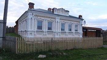
_03.jpg) General view | |
.svg.png) Location of Sverdlovsk Oblast in Russia | |
 Isetskoye | |
| Administrative status | |
| Country | Russia |
| Federal subject | Sverdlovsk oblast |
| Administrative district | Kamensky District |
| Statistics | |
| Population (2010 Census) | 173 inhabitants[1] |
| Time zone | YEKT (UTC+05:00)[2] |
| Founded | 1645 |
| Previous names | Temnovskoe (until 1930) |
| Postal code(s)[3] | 623480 |
| Isetskoye on Wikimedia Commons | |
Isetskoye (Russian: Исетское, Isetskoye) (up to 1930 - Temnovskoye)[4][5][6] - is a village in the Kamensky District of the southern part of the Sverdlovsk oblast, Russia.
Geography
Isetskoye is located 90 km from Yekaterinburg. Maminskoye village administration includes it.
Through the village flows the Iset river. The plot of the Iset River has several rapids and shoals. There are several rafting routes to the Revun rapid. Rocky ridges are visible in the Eastern part of the village — outcrops of volcanic tuff (Greenstone rocks) Silurian system.[7]
As the whole Sverdlovsk oblast Isetskoye is located in the time zone of Ekaterinburg. The offset from UTC is +5:00. Concerning Moscow time the time zone has a constant offset +2 hours and is designated in Russia as MSK+2.
History
Temnaya settlement was founded around 1645 on the left side of the Iset river. Villagers were engaged in farming, carting and trading grain products. In 1702 the village was burnt by Bashkirs.[5] Temnaya was rebuilt in several years. First church was built in 1845. It was named by St. Nicholas. The parish school was opened on March 1886.[8] During the events of The Russian Revolution of 1905 the filial of the social democratic party was established by villagers.
The church`s building was made of wood.The Perm construction division has approved the final stone draft of the new Church in 1913. Construction work was carried out until the Russian Revolution of 1917. Funding was stopped. The priest of St. Nicholas Church was shot by bolsheviks.[9] Later the building of church was burnt and half-destroyed.
Population
| Population of Isetskoe | |||||||
|---|---|---|---|---|---|---|---|
| Year | 1869[10] | 1901 | 1904[11] | 1908 | 1926[12] | 2002[13] | 2010[14] |
| Count | 1022 | 1342 | 1340 | 1641 | 1374 | 206 | 173 |
Transport
There is shuttle bus #102 twice a day (from Kamensk-Uralsky to Sosnovckoe).[15] The nearest railway station is Perebor, 10 kilometers to northeast.[16]
Sightings
.jpg)
- The Church of St. Nicholas
References
- ↑ Russian Federal State Statistics Service (2011). "Всероссийская перепись населения 2010 года. Том 1" [2010 All-Russian Population Census, vol. 1]. Всероссийская перепись населения 2010 года (2010 All-Russia Population Census) (in Russian). Federal State Statistics Service. Retrieved June 29, 2012.
- ↑ Правительство Российской Федерации. Федеральный закон №107-ФЗ от 3 июня 2011 г. «Об исчислении времени», в ред. Федерального закона №271-ФЗ от 03 июля 2016 г. «О внесении изменений в Федеральный закон "Об исчислении времени"». Вступил в силу по истечении шестидесяти дней после дня официального опубликования (6 августа 2011 г.). Опубликован: "Российская газета", №120, 6 июня 2011 г. (Government of the Russian Federation. Federal Law #107-FZ of June 31, 2011 On Calculating Time, as amended by the Federal Law #271-FZ of July 03, 2016 On Amending Federal Law "On Calculating Time". Effective as of after sixty days following the day of the official publication.).
- ↑ Почта России. Информационно-вычислительный центр ОАСУ РПО. (Russian Post). Поиск объектов почтовой связи (Postal Objects Search) (in Russian)
- ↑ "Исетское село Каменского района". Retrieved 2016-03-31.
- 1 2 Словарь-справочник по истории сёл и деревень Каменского района 2000.
- ↑ Приходы и церкви Екатеринбургской епархии 1902.
- ↑ Музей под открытым небом 1997.
- ↑ "2 марта 1886 года открыта церковно-приходская школа". Retrieved 2016-03-12.
- ↑ "Николаевская церковь". Retrieved 2015-11-22.
- ↑ XXXI. Пермская губерния. Список населённых мест по сведениям 1869 года. СПб, 1875. 443 стр.
- ↑ Список населённых мест Пермской губернии 1904 года. Изд. Пермского Губернского земства, Пермь, 1906. 526 стр.
- ↑ Список населённых пунктов Уральской области. Том XVI. Шадринский округ. Свердловск, 1928, 136 стр.(на 32 стр.)
- ↑ База микроданных Всероссийской переписи населения 2002 года
- ↑ Численность населения городских и сельских населённых пунктов Свердловской области по итогам Всероссийской переписи населения 2010 год Archived 2012-08-17 at WebCite
- ↑ "Маршрут Каменск-Уральский — Сосновское". Retrieved 2016-03-15.
- ↑ "Маршрут до ж.д. станции Перебор". Retrieved 2016-03-15.
| Wikimedia Commons has media related to Isetskoe (Sverdlovsk Oblast). |