Isawa Dam
| Isawa Dam | |
|---|---|
 | |
 Location of Isawa Dam in Japan | |
| Location | Iwate Prefecture, Japan |
| Coordinates | 39°06′48.0″N 140°54′13.0″E / 39.113333°N 140.903611°ECoordinates: 39°06′48.0″N 140°54′13.0″E / 39.113333°N 140.903611°E |
| Purpose | Flood control, power, irrigation |
| Construction began | 1983 |
| Opening date | 2013 |
| Dam and spillways | |
| Type of dam | Embankment, rock-fill |
| Impounds | Isawa River |
| Height | 132 m (433 ft) |
| Length | 723 m (2,372 ft) |
| Dam volume | 13,500,000 m3 (17,700,000 cu yd) |
| Reservoir | |
| Total capacity | 143,000,000 m3 (116,000 acre⋅ft) |
| Active capacity | 132,000,000 m3 (107,000 acre⋅ft) |
| Catchment area | 185 km2 (71 sq mi) |
| Surface area | 440 ha (1,100 acres) |
| Power Station | |
| Commission date | 2014 |
| Hydraulic head | 100.7–105.2 m (330–345 ft) (effective) |
| Turbines | 1 × 10.7 MW, 1 × 3.5 MW, 1 × 1.5 MW Francis-type |
| Installed capacity | 15.7 MW[1] |
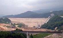
Isawa Dam (胆沢ダム) is an embankment dam on the Isawa River in Iwate Prefecture, Japan.[2] It was constructed between 1983 and 2013. Its reservoir, which submerged the smaller Ishibuchi Dam upstream, was full in May 2013.[3] The dam's 15.7 MW power station was expected to be operational in July 2014.[1]
References
- 1 2 "Isawa first power plant Isawa third power plant" (in Japanese). J-Power. Archived from the original on 20 June 2012. Retrieved 6 June 2013.
- ↑ "Hydropower & Dams in South and East Asia" (PDF). Hydropower and Dams. p. 10. Retrieved 3 October 2010.
- ↑ "Isawa Dam surcharge water level reached!" (in Japanese). Back King. Retrieved 6 June 2013.
| Wikimedia Commons has media related to Isawa Dam. |
This article is issued from
Wikipedia.
The text is licensed under Creative Commons - Attribution - Sharealike.
Additional terms may apply for the media files.