Isahaya, Nagasaki
| Isahaya 諫早市 | |||
|---|---|---|---|
| City | |||
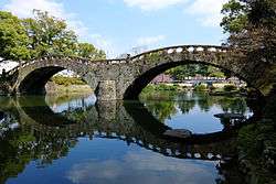 Megane Bridge of Isahaya Park | |||
| |||
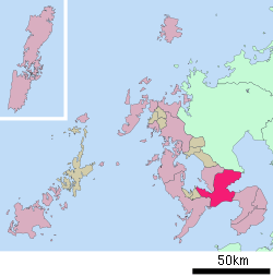 Location of Isahaya in Nagasaki Prefecture | |||
 Isahaya Location in Japan | |||
| Coordinates: 32°51′N 130°4′E / 32.850°N 130.067°ECoordinates: 32°51′N 130°4′E / 32.850°N 130.067°E | |||
| Country | Japan | ||
| Region | Kyushu | ||
| Prefecture | Nagasaki Prefecture | ||
| Government | |||
| • Mayor | Akio Miyamoto (since April 2009) | ||
| Area | |||
| • Total | 320.99 km2 (123.93 sq mi) | ||
| Population (March 1, 2017) | |||
| • Total | 137,160 | ||
| • Density | 430/km2 (1,100/sq mi) | ||
| Symbols | |||
| • Tree | Euonymus hamiltonianus | ||
| • Flower | Rhododendron | ||
| Time zone | UTC+9 (JST) | ||
| City hall address | 854-8601 | ||
| Website |
www | ||


Isahaya (諫早市 Isahaya-shi) is a city located in Nagasaki Prefecture, Japan. The city was founded on September 1, 1940.
As of March 2017, the city has an estimated population of 137,160 and a population density of 430 persons per km². The total area is 320.99 km².
On March 1, 2005, the towns of Tarami, Moriyama, Iimori, Takaki and Konagai (all from Kitatakaki District) were merged to create the new and expanded city of Isahaya. The city was once part of Kitatakaki District, but due to this merger, the district has no more municipalities left and the district was officially dissolved as a result of this merger.
History
In July 1957, a severe downpour within Nagasaki caused a large flood in Isahaya, with over 500 casualties and 3500 injuries reported in Isahaya alone.[1]
Geography
Surrounding municipalities
Education
Isahaya contains a private university, namely the Nagasaki Wesleyan University. Furthermore, Isahaya have five vocational schools, eight high schools, 16 junior high schools and 28 elementary schools in total.
Transportation
Railways
- JR Kyushu
- Nagasaki Main Line: Konagai - Nagasato - Yue - Oe - Hizen-Nagata - Higashi-Isahaya - Isahaya - Nishi-Isahaya - Kikitsu - Ichinuno
- Ōmura Line: Isahaya
- Shimabara Railway
- Shimabara Railway Line: Isahaya - Hon-Isahaya - Saiwai - Onohonmachi - Kantakunosato - Moriyama - Kamanohana - Isahaya-higashi-kōkōmae
Highways
- Nagasaki Expressway
- Japan national route
Sister cities


References
- ↑ "1957年(昭和32) 7月 諫早豪雨". Japan Meteorological Agency (in Japanese). Retrieved 16 September 2018.
External links

- Isahaya City official website (in Japanese)
| Core cities | |||||
|---|---|---|---|---|---|
| Cities |
| ||||
| Districts | |||||