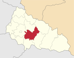
Irshava Raion
| Irshavskyi Raion Іршавський район | |||
|---|---|---|---|
| Raion | |||
| |||
 | |||
| Coordinates: 48°19′12.61″N 23°1′54.16″E / 48.3201694°N 23.0317111°ECoordinates: 48°19′12.61″N 23°1′54.16″E / 48.3201694°N 23.0317111°E | |||
| Country |
| ||
| Region | Zakarpattia Oblast | ||
| Established | January 22, 1946 | ||
| Admin. center | Irshava | ||
| Subdivisions |
List
| ||
| Government | |||
| • Governor | Maksim Mikhaylovich Khokhlov | ||
| Area | |||
| • Total | 944.47 km2 (364.66 sq mi) | ||
| Population (2016) | |||
| • Total | 99,998 | ||
| • Density | 110/km2 (270/sq mi) | ||
| Time zone | UTC+2 (EET) | ||
| • Summer (DST) | UTC+3 (EEST) | ||
| Postal index | 90100 - 90156 | ||
| Area code | 3144 | ||
| Website | carpathia.gov.ua | ||

Irshava Raion (Ukrainian: Іршавський район, Irshavskiy rayon) is a raion (district) in Zakarpattia Oblast of westernmost corner of Ukraine. The only city and the administrative center is Irshava. Irshava Raion is situated on the foothills on the Carpathian Mountains. Population: 99,998 (2016 est.)[1].
See also
References
- ↑ "Чисельність наявного населення України (Actual population of Ukraine)" (PDF) (in Ukrainian). State Statistics Service of Ukraine. Retrieved 19 July 2016.
External links
| Wikimedia Commons has media related to Zakarpattia Oblast. |
- carpathia.gov.ua — Official website of Zakarpattia Oblast Administration (in Ukrainian)/(in English)
- Verkhovna Rada website — Zakarpattia Oblast data
- all.zakarpattya.net — All about Zakarpattia (in English)/(in Ukrainian)
- mukachevo.net — Zakarpattia Oblast informational portal (in Ukrainian)
- map.meta.ua — Digital map of Zakarpattia Oblast (in Ukrainian)
| Raions | |||||
|---|---|---|---|---|---|
| Cities |
| ||||
| |||||
| Oblasts | |
|---|---|
| Cities with special status | |
| Autonomous republic | |
| Administrative centers | |
1Claimed and controlled by Russia as the Republic of Crimea and the Federal City of Sevastopol 2Regions are nearly controlled by Pro-Russian seperatists states of Donetsk People's Republic and Luhansk People's Republic | |
This article is issued from
Wikipedia.
The text is licensed under Creative Commons - Attribution - Sharealike.
Additional terms may apply for the media files.