Ireng River
The Ireng River (or Maú River) forms part of Guyana's western border with Brazil.[1] It flows through the valleys of the Pakaraima Mountains for most of its length. It is the only major river in Guyana which flows from North to South. It is one of the northernmost tributaries of the Amazon river system.
The sources of the river are in the 116,748 hectares (288,490 acres) Monte Roraima National Park, created in 1989.[2] The larger part of the Ireng River basin forms the frontier between Brazil and Guyana. Ireng's main tributaries are the Uailan and Canã rivers on the Brazilian side and the Cacó, Dacã and Socobi rivers on the Guyanese side. All of these rivers merge with the upper and middle sections of the Ireng. Their courses are through breathtaking formations of sedimentary rocks formed by tectonic movements in ancient times. The Ireng River's waters are dark, bearing a striking resemblance to that of Rio Negro near Manaus, in Brazilian state of Amazonas.
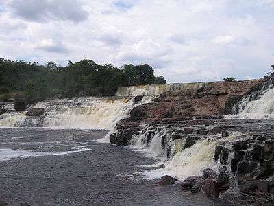
It is considered to be the most picturesque of Guyana's many rivers. Orinduik Falls and Takagka Falls are located on the Ireng River.
.JPG)
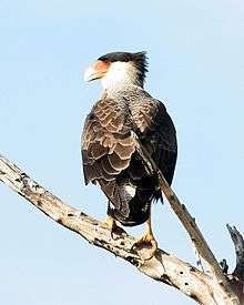
Biodiversity in the Ireng
The Ireng River region is home to such reptile species as the Antilles Leaf-toed Gecko (Hemidactylus palaichthus)and Rainbow Whiptail (Cnemidophorus lemniscatus); amphibians such as The Sapo Dorado (Bufo guttatus) and Leptodactylus bolivianus; birds including The Muscovy Duck (Cairina moschata), The Black Vulture (Coragyps atratus), The Southern Crested Caracara (Caracara plancus), The Double-striped Thick-knee (Burhinus bistriatus)and numerous other; mammals include The South American tapir (Tapirus terrestris),jaguar (Panthera onca) and the red-rumped agouti (Dasyprocta leporina).[1]
.jpg)
References
- 1 2 "Barbosa, R.I.; Nascimento, S.P.; Weiduschat, A.A.; Bonatto, F. 2013. Notes on an exploratory expedition to the headwaters of the Mau (Ireng) river, Northern Brazilian Amazon. Boletim do Museu Integrado de Roraima, 7(2): 45-54". Retrieved 2 January 2014.
- ↑ Unidade de Conservação: Parque Nacional do Monte Roraima (in Portuguese), MMA: Ministério do Meio Ambiente, retrieved 2016-06-07