Iput River
| Iput Russian: Ипуть | |
|---|---|
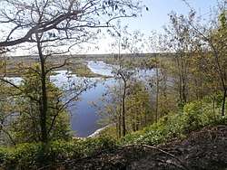 The Iput in Dobrush | |
| Country | Russia, Belarus |
| Physical characteristics | |
| River mouth | Sozh |
| Length | 437 km (272 mi) |
| Official name | Iput River Floodplain |
| Designated | 30 March 2015 |
| Reference no. | 2262[1] |
The Iput, or Ipuć[2] (Belarusian: Іпуць, [iput͡sʲ]; Russian: Ипуть) is a river in Mogilev and Gomel Regions in Belarus and Smolensk and Bryansk Oblasts in Russia. It is a left tributary of the Sozh River. The length of the Iput River is 437 kilometres (272 mi).[3] The area of its basin is 10,900 square kilometres (4,200 sq mi). It freezes up in late November and stays icebound until late March to early April. Its main tributaries are the Voronitsa and Unecha Rivers. The towns of Surazh and Dobrush are located on the Iput River.
The source of the Iput is in Mogilev Region of Belarus. It flows east and enters Russia, where it makes the border between Shumyachsky and Yershichsky Districts of Smolensk Oblast. Close to the village of Shadoga it departs of the border and flows southeast, flowing through the selo of Yershichi, and flows south downstrean of Yershichi. A stretch of the Iput, flowing southwest, makes a border between Smolensk Oblast (Yershichsky District) and Bryansk Oblast (Kletnyansky District). Downstream of the selo of Korsiki the Iput departs south of the border and flows south through Kletnyansky District, accepts the Nadva from the left, crosses the northern part of Mglinsky District and makes the border between Mglinsky and Surazhsky Districts. It further flows southwest through Surazhsky District and the town of Surazh and makes the border between Surazhsky and Klintsovsky Districts, and further downstream between Gordeyevsky and Klintsovsky Districts. Downstream, it crosses the western part of Klintsovsky District, makes a border between Klintsovsky and Novozybkovsky Districts, crosses Novozybkovsky and Zlynkovsky Districts and flows to Belarus. the mouth of the Iput is in the city of Gomel.
A stretch of the Iput 20 kilometres (12 mi) west of Klintsy is a protected birds sanctuary.[4]
Coordinates: 52°25′44″N 31°03′04″E / 52.42889°N 31.05111°E
References
- ↑ "Iput River Floodplain". Ramsar Sites Information Service. Retrieved 25 April 2018.
- ↑ official transliteration
- ↑ "Гидрография Брянской области" (in Russian). Институт Озероведения РАН. Retrieved 31 January 2018.
- ↑ "Река Ипуть" (in Russian). Ecological Map of Russia. Retrieved 31 January 2018.