Ipf (mountain)
| Ipf | |
|---|---|
 Ipf | |
| Highest point | |
| Elevation | 668 m (2,192 ft) |
| Coordinates | 48°52′14″N 10°21′23″E / 48.87056°N 10.35639°ECoordinates: 48°52′14″N 10°21′23″E / 48.87056°N 10.35639°E |
| Geography | |
 Ipf Location within Baden-Württemberg | |
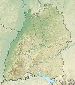
| Location | Baden-Württemberg, Germany |
| Parent range | Swabian Jura |
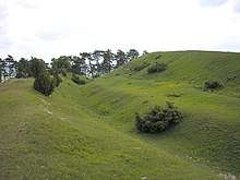
Prehistoric wall on the northern hillside

This aerial image shows the extensive fortification on the Ipf
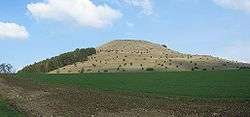
The Ipf is a mostly treeless mountain (668 metres), near Bopfingen, Ostalbkreis, Baden-Württemberg, Germany with a prehistoric hill fort on its top.
The fort is situated on an isolated hill, with a flattened summit surrounded by a stone wall, ditch and large counterscarp (outer bank). The overall diameter is about 180 metres. There are also extensive ramparts traversing the slopes to protect a large enclosed area and entranceway. There is evidence of occupation from the Bronze Age through the Iron Age to the early Celtic La Tene period, a span of almost a thousand years (1200 BC - 300 BC).[1]
References
- ↑ F. Hertlein: Die vorgeschichtlichen Befestigungen auf dem Ipf. Blätter des Schwäbischen Albvereins, 23. Jg. (1911), Nr. 2, S. 48–55 und Nr. 3, S. 68–74.
This article is issued from
Wikipedia.
The text is licensed under Creative Commons - Attribution - Sharealike.
Additional terms may apply for the media files.