Ipeľ
| Ipeľ (Ipoly) | |
| River | |
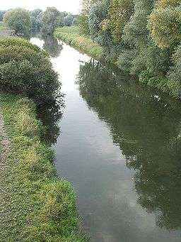 Ipeľ river near Šahy | |
| Countries | Slovakia, Hungary |
|---|---|
| Tributaries | |
| - right | Krtíš |
| Source | |
| - location | Lom nad Rimavicou, Slovakia |
| Mouth | Danube River |
| - location | Chľaba/Szob |
| Length | 232 km (144 mi) |
| Basin | 5,151 km2 (1,989 sq mi) |
| Discharge | mouth |
| - average | 21 m3/s (742 cu ft/s) |
| - max | 70 m3/s (2,472 cu ft/s) |
| - min | 3 m3/s (106 cu ft/s) |
| Progression | Danube→ Black Sea |
The Ipeľ (Slovak; pronounced [ˈipɛʎ]) or Ipoly (Hungarian) (German: Eipel, archaic Slovak: Jupoľ, Latin:Bolia[1][2]) is a 232-kilometre (144 mi) long river in Slovakia and Hungary, a tributary of the Danube River. Its source is in central Slovakia in the Slovak Ore Mountains. It flows south to the Hungarian border, and then southwest, west, and again south along the border until it flows into the Danube near Szob.
The Ipeľ flows through or creates the border of the Banská Bystrica and Nitra regions in Slovakia, and Nógrád and Pest counties in Hungary.
Towns and villages
The following towns and villages are situated on the river, in downstream order:
- Poltár (SK)
- Kalinovo (SK)
- Boľkovce (SK)
- Ipolytarnóc (HU)
- Litke (HU)
- Nógrádszakál (HU)
- Szécsény (HU)
- Balassagyarmat (HU)
- Ipolyvece (HU)
- Ipeľské Predmostie (SK)
- Šahy (SK)
- Vámosmikola (HU)
- Pastovce (SK)
- Ipolytölgyes (HU)
- Salka (SK)
- Letkés (HU)
- Ipolydamásd (HU)
- Szob (HU)
Notes and references
- ↑ Pohl, W. (1980). "Die Gepiden und die Gentes an der mittleren Donau nach dem Zerfall des Attilareiches". In Wolfram, Herwig; Daim, Falko. Die Völker an der mittleren und unteren Donau im fünften und sechsten Jahrhundert. Berichte des Symposions der Kommission für Frühmitel-lalterforschung 24. bis 27. Oktober 1978, Stift Zwettl, Niederösterreich (in German). Vienna, Austria: Kommission für Frühmittelalterforschung, Österreichischen Akademie der Wissenschaften. pp. 239–305, page 266. ISBN 978-3-7001-0353-0.
- ↑ Wolfram, Herwig (1990). "The Ostrogothic Kingdom in Pannonia". History of the Goths. Berkeley, California: University of California Press. p. 264. ISBN 978-0-520-06983-1.
| Wikimedia Commons has media related to Ipoly. |
| Countries | 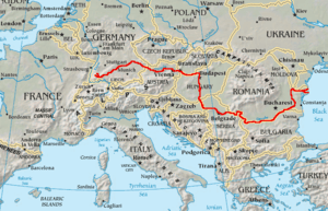 | |
|---|---|---|
| Cities | ||
| Tributaries | ||
| See also | ||
Coordinates: 47°49′06″N 18°50′55″E / 47.8182°N 18.8485°E
This article is issued from
Wikipedia.
The text is licensed under Creative Commons - Attribution - Sharealike.
Additional terms may apply for the media files.