Inveralligin
Inveralligin
| |
|---|---|
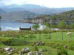 Ruin overlooking Ob a' Bhraighe Taken from Wester Alligin. | |
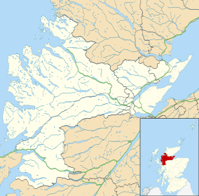 Inveralligin Inveralligin shown within the Ross and Cromarty area | |
| OS grid reference | NG841575 |
| Council area | |
| Country | Scotland |
| Sovereign state | United Kingdom |
| Postcode district | IV22 2 |
| Police | Scottish |
| Fire | Scottish |
| Ambulance | Scottish |
| EU Parliament | Scotland |
| UK Parliament | |
| Scottish Parliament | |
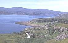
Inveralligin (Scottish Gaelic: Inbhir Àiliginn) is a remote crofting township which lies on the north shore of Loch Torridon in Wester Ross[1] and is in the Scottish council area of Highland. Inbhir Àiliginn means "at the mouth of the River Alligin".
Torridon lies to the east and Lower Diabaig about 5 kilometres (3.1 mi) to the west. Alligin Shuas lies immediately to the west. This name is also of Gaelic origin: alligin may be from àilleag meaning "jewel" and shuas means "western" or "upper".[2]
References
- ↑ "Inveralligin". The Gazetteer for Scotland. School of GeoSciences, University of Edinburgh and The Royal Scottish Geographical Society. Retrieved 4 July 2018.
- ↑ Iain Mac an Tàilleir. "Placenames" (PDF). Pàrlamaid na h-Alba. pp. 4, 118. Archived from the original (PDF) on 2008-05-29. Retrieved 2007-07-23.
Inveralligin
This article is issued from
Wikipedia.
The text is licensed under Creative Commons - Attribution - Sharealike.
Additional terms may apply for the media files.