Intuition Peak


Intuition Peak (Vrah Intuitsiya \'vr&h in-tu-'i-tsi-ya\) is a sharp Antarctic peak of elevation 780 m in Levski Ridge, Tangra Mountains on Livingston Island in the South Shetland Islands, Antarctica. It is surmounting Iskar Glacier to the east and Devnya Valley to the west. The peak was named in appreciation of the role of scientific intuition for the advancement of human knowledge.
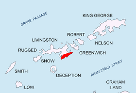
Location
The cliff is located at 62°38′38.8″S 60°02′07″W / 62.644111°S 60.03528°WCoordinates: 62°38′38.8″S 60°02′07″W / 62.644111°S 60.03528°W which is 1.39 km north by west of Helmet Peak, 5.25 km southeast of Atanasoff Nunatak and 630 m west-southwest of Radoy Ralin Peak (Bulgarian mapping in 2005 and 2009 from the Tangra 2004/05 topographic survey).
Maps
- L. L. Ivanov et al. Antarctica: Livingston Island and Greenwich Island, South Shetland Islands. Scale 1:100000 topographic map. Sofia: Antarctic Place-names Commission of Bulgaria, 2005.
- L. L. Ivanov. Antarctica: Livingston Island and Greenwich, Robert, Snow and Smith Islands. Scale 1:120000 topographic map. Troyan: Manfred Wörner Foundation, 2009. ISBN 978-954-92032-6-4
- Antarctic Digital Database (ADD). Scale 1:250000 topographic map of Antarctica. Scientific Committee on Antarctic Research (SCAR). Since 1993, regularly upgraded and updated.
- L.L. Ivanov. Antarctica: Livingston Island and Smith Island. Scale 1:100000 topographic map. Manfred Wörner Foundation, 2017. ISBN 978-619-90008-3-0
References
- Intuition Peak. SCAR Composite Antarctic Gazetteer
- Bulgarian Antarctic Gazetteer. Antarctic Place-names Commission. (details in Bulgarian, basic data in English)
This article includes information from the Antarctic Place-names Commission of Bulgaria which is used with permission.