Ingleburn, New South Wales
| Ingleburn Sydney, New South Wales | |||||||||||||||
|---|---|---|---|---|---|---|---|---|---|---|---|---|---|---|---|
 Ingleburn | |||||||||||||||
|
Ingleburn | |||||||||||||||
| Coordinates | 33°59′8″S 150°51′13″E / 33.98556°S 150.85361°ECoordinates: 33°59′8″S 150°51′13″E / 33.98556°S 150.85361°E | ||||||||||||||
| Population | 15,039 (2016 census)[1] | ||||||||||||||
| Established | 1883 | ||||||||||||||
| Postcode(s) | 2565 | ||||||||||||||
| Location | 40 km (25 mi) south-west of Sydney CBD | ||||||||||||||
| LGA(s) | City of Campbelltown | ||||||||||||||
| State electorate(s) | Macquarie Fields | ||||||||||||||
| Federal Division(s) | |||||||||||||||
| |||||||||||||||

Ingleburn is a suburb of Sydney, in the state of New South Wales, Australia 40 kilometres south-west of the Sydney central business district, in the local government area of City of Campbelltown. It is part of the Macarthur region. Ingleburn is located approximately halfway between the two commercial centres of Liverpool and Campbelltown.
History
The land in the Ingleburn area was originally inhabited by the Tharawal people prior to the arrival of settlers from the First Fleet in 1788.[2][3] The first land grants in the area were made in 1809 to William Hall, William Neale, Joshua Alliot and Timothy Loughlin, all previously soldiers in the NSW Corps. As such, the area became known as "Soldier Flat".[4]
In 1869, a rail platform was built on the old Neale grant and given the name Macquarie Fields Station after a property to the north. However, in 1881 the Macquarie Fields estate subdivided to become the new village of Macquarie Fields. The fact that the station was a long way from the village caused confusion so a new name was sought for the station and Ingleburn was chosen in 1883. One theory has it was named after a local house formerly owned by Mary Ruse, daughter of pioneer James Ruse. Other records indicate it was named after a British town although the corresponding town hasn't been identified. Ingleburn is Scottish for "bend in the river", referring to the significant bend in the nearby Georges River.
The village of Ingleburn was established in 1885 when the land owned by a developer called FitzStubbs was subdivided. A public school was opened in 1887. Ingleburn Post Office opened on 15 November 1886.[5] By 1896, the town was large enough to have its own municipal council. Town improvements such as street lights and water did not arrive until after World War I. In 1948 the Council was merged with the City of Campbelltown Council.
In 1969, a large area west of the railway line was rezoned to become an industrial estate. Protests from local residents saw the plan halted temporarily but within ten years, the west side of the town had become largely industrial and remains so to this day. More housing subdivisions were made on the outskirts of town in the 1970s including Housing Commission developments.
Heritage listings
Ingleburn has a number of heritage-listed sites, including:
- Campbelltown Road: Ingleburn Military Heritage Precinct and Mont St Quentin Oval[6]
- 196 Campbelltown Road: Robin Hood Farm[7]
Commercial areas
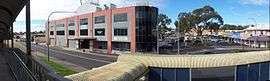
Ingleburn's central business district is adjacent to the railway station and includes two shopping centres called Ingleburn Fair and Ingleburn Town Centre as well as a small shopping area on Lagonda Drive. In 2017 Ingleburn Mall was renovated and many new stores were added and relocated.
Ingleburn is the home of television playout centre MediaHub, a facility established through a joint partnership with WIN Television and ABC Television. Apart from the two networks, it also houses HD-ready playout for Prime7, Imparja Television, and Fox International channels.
Transport
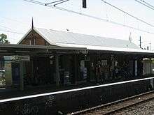
Ingleburn is home to the heritage-listed Ingleburn railway station.[8] The station is serviced by the Airport & South Line on the Sydney Trains network.
Bus services to and from Ingleburn are provided by Interline bus service.
Street names
Ingleburn has many themes for the naming of streets. Chester Road, Cumberland Road, Cambridge Street, Oxford Road, Suffolk Street, Carlisle Street, Norfolk Street Raglan Avenue, Belford Street, Salford Street and Phoenix Avenue were some of the first streets in the town and are named after English localities.
Birds are another theme with the main thoroughfares Warbler Avenue, Lorikeet Avenue, Currawong Street, Kingfisher Street, Oriole Place, Wagtail Crescent and Kookaburra Street, and smaller streets named after the magpie, jabiru, falcon, lark, ibis, dove, egret, kestrel, swift, heron, miner, jacana, honeyeater, lyrebird, whistler, fantail, swallow, sitella, brolga, swan, owl, quail, and triller.
There is also a car theme with Lancia Drive, Lagonda Drive, Bugatti Drive, Mercedes Road, Maserati Drive and Peugeot Drive becoming main thoroughfares and Fiat, Ferrari, Cadillac, Ford, Alfa, Renault, Rambler, Vauxhall, Buick, Leyland, Delaunay, Daimler, Stutz, Morgan, Sunbeam Place, Pontiac Place, Chevrolet Place, Delage Place and Oldsmobile Place being named after cars too.
Schools
- Ingleburn North Public School
- Ingleburn Public School
- Ingleburn High School
- Sackville Street Public School
- Holy Family Primary School. (Catholic)
Parks and recreation
Milton Park, shared by the boundaries of Ingleburn and Macquarie Fields is a popular venue for football and softball teams. It is also used as the presentation area for the annual Ingleburn Alive festival's evening fireworks.
Other sporting parks include Wood Park, behind Ingleburn High School where rugby league and cricket are played.
Smaller recreational reserves and parks are located between Kingfisher Road and Currawong Street, on Matthew Square, on Currawong Street behind Holy Family Catholic School and another behind Sackville Street Public School.
Memorial Oval can also be found on the western side of the railway line adjacent to the Ingleburn Bowling Club.
Ingleburn RSL is located on Chester Road. Annually at dawn on ANZAC Day, a service is held to remember those that lost their lives serving for Australia.
Population
At the 2011 census, there were 13,902 residents in Ingleburn. 39.6% of people were born outside of Australia, with the top countries of birth being India 4.1%, Philippines 3.8%, England 3.5%, New Zealand 2.7% and Bangladesh 2.6%. Around one third of residents spoke a language other than English at home. The most common languages spoken were Bengali 3.5%, Hindi 2.7%, Tagalog 2.4% and Arabic 2.0%.[1]
References
- 1 2 Australian Bureau of Statistics (27 June 2017). "Ingleburn (State Suburb)". 2016 Census QuickStats. Retrieved 14 March 2018.

- ↑ "Campbelltown's environment" (PDF). Campbelltown City Council. Archived from the original (PDF) on 13 September 2006. Retrieved 2008-01-25.
- ↑ "History of Camden". Camden Historical Society. Retrieved 2008-01-25.
- ↑ "History of Ingleburn". Campbelltown City Council. Retrieved 2007-08-17.
- ↑ Premier Postal History. "Post Office List". Premier Postal Auctions. Retrieved 16 June 2012.
- ↑ "Ingleburn Military Heritage Precinct and Mont St Quentin Oval, New South Wales State Heritage Register (NSW SHR) Number H01891". New South Wales State Heritage Register. Office of Environment and Heritage. Retrieved 18 May 2018.
- ↑ "Robin Hood Farm, New South Wales State Heritage Register (NSW SHR) Number H01387". New South Wales State Heritage Register. Office of Environment and Heritage. Retrieved 18 May 2018.
- ↑ http://www.heritage.nsw.gov.au/07_subnav_04_2.cfm?itemid=4801088 | Heritage NSW
External links
| Wikimedia Commons has media related to Ingleburn, New South Wales. |