Indiantown, Florida
| Indiantown, Florida | |
|---|---|
| Village | |
 Modern Indiantown | |
 Location in Martin County and the state of Florida | |
| Coordinates: 27°2′N 80°28′W / 27.033°N 80.467°WCoordinates: 27°2′N 80°28′W / 27.033°N 80.467°W | |
| Country |
|
| State |
|
| County | Martin |
| Area | |
| • Total | 6 sq mi (15.5 km2) |
| • Land | 6 sq mi (15.5 km2) |
| • Water | 0 sq mi (0 km2) |
| Elevation | 33 ft (10 m) |
| Population (2010) | |
| • Total | 6,083 |
| • Density | 931.3/sq mi (360.5/km2) |
| Time zone | UTC-5 (Eastern (EST)) |
| • Summer (DST) | UTC-4 (EDT) |
| ZIP code | 34956 |
| Area code(s) | 772 |
| FIPS code | 12-33700[1] |
| GNIS feature ID | 0294216[2] |
Indiantown is a village in Martin County, Florida, United States. The population was 6,083 at the 2010 census. It is part of the Port St. Lucie Metropolitan Statistical Area.
History

Indiantown was originally established by the Seminole people as a trading post. Tribes fleeing southwards from the US Army after the First Seminole War found the area an attractive place to settle due to a relatively higher elevation and ample hunting and fishing spots. It was then settled by white American migrants in the 1890s.[3]
Old Indiantown Road - Within Timer Powers Park, you will find a historical marker sign that details Jupiter Indiantown Road as it existed from the 1900s until the late 1950s. Inscription from the sign: From 1900 until the late 1950s, the Jupiter Indiantown Road connected the communities of Jupiter and Indiantown, giving residents access to resources. Dade County governed the area in 1899, when the new road was cut. In Indiantown about that time, brothers Joe and Dessie Bowers developed citrus groves and ran a trading post exchanging goods for hides with the Seminoles. Transportation of goods on the 16-mile road took two days by oxcart. The road was improved in 1912 using mules to haul shell rock from Jupiter. Around 1916 the St. Lucie Canal intersected the road near Indiantown. A hand winched ferry provided cross passage until a one-lane turning bridge was built in 1927. Homesteads, cattle ranches, and later the Davis and Jenkins sawmill were established along the road. Also known as the Jupiter Grade Road, the Jupiter Okeechobee Road and the Central Dixie Highway, in 1936 it became State Road 29. By the late 1950s nearby paved highways replaced the historic dirt road. In 1993 the road was declared a Scenic By-Way by Martin and Palm Beach Counties. (Erected: F-581 "A Florida Heritage Site Sponsored by the Martin County Board of County Commissioners and the Florida Department of State" 2006)
In 1924, Indiantown was transformed when S. Davies Warfield built an extension of the Seaboard Air Line Railway from Coleman, Florida to West Palm Beach, passing directly through—and stopping in—Indiantown.[4]
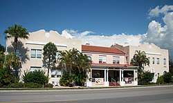
Warfield planned to make Indiantown the southern hub of the Seaboard rail line.[4][5] Toward that end, he planned a model city, laying out streets and building a school, housing, and a railroad station.[3][5] Warfield also built the Seminole Inn, which is now on the National Register of Historic Places.[5]
However, the Florida land boom of the 1920s fizzled out after 1926. Warfield died a year later, putting an end to plans to make Indiantown the Seaboard's southern headquarters.[5] The 1928 Okeechobee hurricane wreaked significant destruction and halted further development.
A serious effort to revitalize the local economy began in 1952 when the Indiantown Development Corporation was sold and restructured as the Indiantown Company. The Company was involved in the construction of new water and sewage systems, housing developments, docks making use of the St. Lucie River, and a 6000 foot airstrip for bringing in small cargo and civilian air traffic.
In the 1950s and 1960s Indiantown was home to the Circle T Ranch, and its Circle T Rodeo Bowl. The 1963 Rodeo event drew approximately 15000 visitors, making it the largest tourist attraction in Florida at the time. The Ranch would later be bought out and turned into a filming studio.[6]
Seaboard trains continued to stop at the Indiantown depot through the 1960s but passenger service to the station was eliminated when Amtrak took over in 1971. The depot was demolished several years later. The Seminole Inn is virtually all that remains of the 1920s boom.[3]
Warfield's contributions to Indiantown are memorialized in, among others, Warfield Boulevard (the main route through Indiantown) and Warfield Elementary School.[4]
Currently, the economy of Indiantown relies heavily on seasonal agriculture. The town also continues to make use of its position near the intersections of many major roads to act as a transportation and infrastructure hub. There are also attempts to take advantage of nearby natural wetlands and to revitalize the Rodeo in order to draw in tourists.[7]
Geography
Indiantown is located at 27°2′N 80°28′W / 27.033°N 80.467°W (27.0263, -80.4728).[8]
According to the United States Census Bureau, the Village has a total area of 6.0 square miles (16 km2), all land.
Demographics
As of the census[1] of 2000, there were 5,588 people, 1,648 households, and 1,264 families residing in the Village. The population density was 936.2 people per square mile (361.4/km²). There were 1,807 housing units at an average density of 302.7/sq mi (116.9/km²). The racial makeup of the Village was 45.92% White, 20.99% African American, 2.29% Native American, 0.20% Asian, 0.97% Pacific Islander, 26.54% from other races, and 3.10% from two or more races. Hispanic or Latino of any race were 48.93% of the population.
There were 1,648 households out of which 33.7% had children under the age of 18 living with them, 54.9% were married couples living together, 13.7% had a female householder with no husband present, and 23.3% were non-families. 17.2% of all households were made up of individuals and 9.9% had someone living alone who was 65 years of age or older. The average household size was 3.39 and the average family size was 3.59.
In the Village, the population was spread out with 31.2% under the age of 18, 11.4% from 18 to 24, 25.6% from 25 to 44, 15.7% from 45 to 64, and 16.2% who were 65 years of age or older. The median age was 30 years. For every 100 females, there were 123.0 males. For every 100 females age 18 and over, there were 123.2 males.
The median income for a household in the Village was $28,977, and the median income for a family was $30,675. Males had a median income of $17,810 versus $19,063 for females. The per capita income for the Village was $11,085. About 18.8% of families and 23.8% of the population were below the poverty line, including 31.3% of those under age 18 and 7.0% of those age 65 or over.
Government
Indiantown is a Village located in Martin County, governed by a VIllage Council of 5. Martin County is divided into 5 districts. Indiantown is represented by Harold Jenkins on the District 3 side and Ed Ciampi on the District 5 side.
Public transportation
Indiantown is served by a shuttle around Indiantown, operated by Martin County.[9][10]
Payson Park
Indiantown is the home of Payson Park, one of the top thoroughbred horse racing facilities in the United States. Among the trainers with their champion horses who have participated in this event are William Mott, Christophe Clement, Roger Attfield, Shug McGaughey, John Kimmel, and Tom Albertrani. Monkees frontman Davy Jones also kept a stable of Thoroughbred horses in Indiantown, and it was here that he died in 2012.

Notable people
- Cleveland Gary, professional football player
- Charles Emanuel, professional football player
- Patrick Sheltra, 2010 ARCA Racing Series racing champion
- Davy Jones, musician and actor from The Monkees[11]
- Corey McIntyre, professional football player
Notes
- 1 2 "American FactFinder". United States Census Bureau. Retrieved 2008-01-31.
- ↑ "US Board on Geographic Names". United States Geological Survey. 2007-10-25. Retrieved 2008-01-31.
- 1 2 3 "Indiantown - Ghost Town". Retrieved 2011-10-31.
- 1 2 3 McIver. 198
- 1 2 3 4 Eliot Kleinberg (2010-12-30). "Seminole Inn not site of royal honeymoon". palmbeachpost.com. Retrieved 2011-10-31.
- ↑ Matthews Rey, Carol (2014). Images of America: Indiantown. Charleston, South Carolina: Arcadia Publishing. ISBN 978-1-4671-1131-7.
- ↑ "Indiantown Chamber of Commerce". Indiantown Chamber of Commerce Homepage. Retrieved 22 October 2017.
- ↑ "US Gazetteer files: 2010, 2000, and 1990". United States Census Bureau. 2011-02-12. Retrieved 2011-04-23.
- ↑ "Martin County - your county, your community". Retrieved 17 November 2016.
- ↑ "- Martin County" (PDF). Retrieved 17 November 2016.
- ↑ http://www.wptv.com/news/region-martin-county/davy-jones-lead-singer-of-the-monkees-dies-from-heart-attack-this-morning-according-to-tmz-report
References
| Wikivoyage has a travel guide for Indiantown. |
| Wikimedia Commons has media related to Indiantown, Florida. |
- McIver, Stuart B. (1994) Dreamers, Schemers and Scalawags. Sarasota, Florida: Pineapple Press, Inc. ISBN 1-56164-034-4
Municipalities and communities of Martin County, Florida, United States | ||
|---|---|---|
| City | 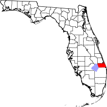 | |
| Towns | ||
| Village | ||
| CDPs | ||
| Unincorporated community | ||