Indianola, Utah
| Indianola | |
|---|---|
| Unincorporated community | |
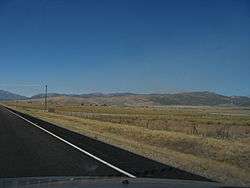 Indianola in 2010 | |
 Indianola Location within the state of Utah | |
| Coordinates: 39°48′11″N 111°29′20″W / 39.80306°N 111.48889°WCoordinates: 39°48′11″N 111°29′20″W / 39.80306°N 111.48889°W | |
| Country | United States |
| State | Utah |
| County | Sanpete |
| Settled | 1871 |
| Elevation[1] | 5,961 ft (1,817 m) |
| Time zone | UTC-7 (Mountain (MST)) |
| • Summer (DST) | UTC-6 (MDT) |
| ZIP code | 84629 |
| Area code(s) | 435 |
| GNIS feature ID | 1442039[1] |
| Historical population | |||
|---|---|---|---|
| Census | Pop. | %± | |
| 1890 | 148 | — | |
| 1900 | 119 | −19.6% | |
| 1910 | 127 | 6.7% | |
| 1920 | 222 | 74.8% | |
| 1930 | 114 | −48.6% | |
| 1940 | 70 | −38.6% | |
| 1950 | 61 | −12.9% | |
| Source: U.S. Census Bureau[2] | |||
Indianola is an unincorporated community in Sanpete County, Utah, United States, east of U.S. Route 89 at Thistle Creek and 12 miles (19 km) northeast of Fairview. An early Native American village existed here, and in pioneer times the site was selected for a Native American reservation.
The town of Indianola was settled in 1871.
Climate
This climatic region is typified by large seasonal temperature differences, with warm to hot (and often humid) summers and cold (sometimes severely cold) winters. According to the Köppen Climate Classification system, Indianola has a humid continental climate, abbreviated "Dfb" on climate maps.[3]
References
- 1 2 U.S. Geological Survey Geographic Names Information System: Indianola, Utah. Retrieved May 19, 2011.
- ↑ "Census of Population and Housing". U.S. Census Bureau. Archived from the original on February 8, 2006. Retrieved November 4, 2011.
- ↑ Climate Summary for Indianola, Utah
Municipalities and communities of Sanpete County, Utah, United States | ||
|---|---|---|
| Cities | 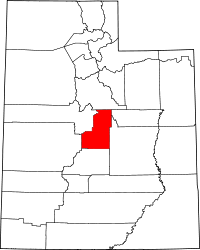 | |
| Towns | ||
| Unincorporated communities | ||
| Ghost towns | ||
This article is issued from
Wikipedia.
The text is licensed under Creative Commons - Attribution - Sharealike.
Additional terms may apply for the media files.