Indiana State Road 342
| ||||
|---|---|---|---|---|
 | ||||
| Route information | ||||
| Maintained by INDOT | ||||
| Length | 0.35 mi[1] (0.56 km) | |||
| Major junctions | ||||
| South end | Air National Guard at Terre Haute | |||
| North end |
| |||
| Highway system | ||||
| ||||

State Road 342 is a north–south road in Vigo County, Indiana. It is less than a half mile (kilometer) long.
Route description
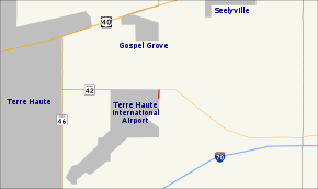
State Road 342 is a spur of State Road 42. It begins at the entrance to the Indiana Air National Guard's 181st Fighter Wing, housed at Terre Haute International Airport, and runs north to its parent route. North of State Road 42, the line of the route continues on Chamberlain Street.
Major intersections
The entire route is in Terre Haute, Vigo County.
| mi[2] | km | Destinations | Notes | ||
|---|---|---|---|---|---|
| 0.00 | 0.00 | Southern terminus of SR 342 | |||
| 0.35 | 0.56 | Northern terminus of SR 342 | |||
| 1.000 mi = 1.609 km; 1.000 km = 0.621 mi | |||||
References
- ↑ Indiana Department of Transportation (2004). Reference Post Book (PDF). Indianapolis: Indiana Department of Transportation. S 342. Archived (PDF) from the original on October 6, 2014. Retrieved October 15, 2012.
- ↑ "INDOT Roadway Referencing System" (PDF). staff. Archived from the original (PDF) on 2011-06-15.
External links
Route map:
This article is issued from
Wikipedia.
The text is licensed under Creative Commons - Attribution - Sharealike.
Additional terms may apply for the media files.