Imerovigli, Othoni
| Imerovigli | |
|---|---|
 Imerovigli highest peak | |
| Highest point | |
| Elevation | 393 m (1,289 ft) |
| Coordinates | 39°50′42″N 19°23′15″E / 39.84500°N 19.38750°ECoordinates: 39°50′42″N 19°23′15″E / 39.84500°N 19.38750°E |
| Geography | |
 Imerovigli | |
| Parent range | Ano panta, Othoni |
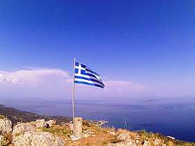
Imerovigli (or Merovigli) is the highest mountain of the island of Othoni, located in the Diapontia Islands, northwest of Corfu. It is about 2 km from the settlement Chorio. It has a height that exceeds 390 meters and is accessible by a traditional path (~ 1300 meters long) leading to the top of the mountain where every visitor can observe the view of the Ionian and Adriatic sea.[1]
References
- ↑ "Ένωσαν δυνάμεις και άνοιξαν το μονοπάτι προς το Μεροβίγγλι Οθωνών". newmail.gr. [Iούνιος 2016]. Retrieved 2016-10-25. Check date values in:
|date=(help)
This article is issued from
Wikipedia.
The text is licensed under Creative Commons - Attribution - Sharealike.
Additional terms may apply for the media files.