Iluileq
 Iluileq | |
| Geography | |
|---|---|
| Location |
North Atlantic Ocean Southern Greenland |
| Coordinates | 60°52′N 42°48′W / 60.867°N 42.800°WCoordinates: 60°52′N 42°48′W / 60.867°N 42.800°W |
| Highest elevation | 829 m (2,720 ft) |
| Highest point | Nûgâlik |
| Administration | |
|
Greenland | |
| Municipality | Kujalleq |
| Demographics | |
| Population | 0 |
Iluileq (named 'Ilivilik' in old maps) is an uninhabited island in the Kujalleq municipality in southern Greenland.
Geography
Iluileq is a coastal island that lies off King Frederick VI Coast in southeastern Greenland. It is located at the head of Iluileq Fjord (Danell Fjord), on the northern side of it. A smaller narrow fjord separates Iluileq from the mainland on its NW side.[1] The island's length is 19 kilometres (12 miles) and its maximum width 5.8 kilometres (4 miles).
Iluileq has rugged cliffs, its highest point reaching 829 metres (2,720 feet). Off the eastern end of the island's coast lies Cape Discord (Kangeq) and off its southern shore lies the small cluster of islets named Ivingmiut.[2]
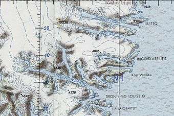 Map of Greenland section showing Iluileq Island. |
See also
References
External links
This article is issued from
Wikipedia.
The text is licensed under Creative Commons - Attribution - Sharealike.
Additional terms may apply for the media files.