Ilha Rasa Lighthouse
 Ilha Rasa Lighthouse | |
 Brazil | |
| Location | Ilha Rasa |
|---|---|
| Coordinates | 23°03′50″S 43°08′45″W / 23.063919°S 43.145920°WCoordinates: 23°03′50″S 43°08′45″W / 23.063919°S 43.145920°W |
| Year first constructed | 1829 |
| Foundation | stone base |
| Construction | stone tower |
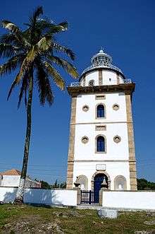
| Tower shape | cylindrical tower with balcony and lantern atop a massive square tower |
| Markings / pattern | white tower with brown trim |
| Height | 26 metres (85 ft)[1] |
| Focal height | 101 metres (331 ft)[1] |
| Range |
white: 51 nautical miles (94 km; 59 mi) red: 45 nautical miles (83 km; 52 mi)[2] |
| Characteristic | Al Fl (2) W (1) R 15s.[2] |
| Admiralty number | G0360[2] |
| NGA number | 18372[2] |
| ARLHS number | BRA-047[1] |
| Brazil number | BR-2420[1] |
| Managing agent | Brazilian Navy |
Ilha Rasa Lighthouse (Portuguese: Farol da Ilha Rasa) is an active lighthouse on the namesake island located 11 kilometres (6.8 mi) from Guanabara Bay, Rio de Janeiro, Brazil.
History
Before the construction of the lighthouse a fire was lit every night on the summit of Ilha Rasa signalling the entrance to the Port of Rio de Janeiro. João VI decided the construction of the lighthouse on the island and the works began in 1819 employing prisoners as workforce under the supervision of the engineer João de Souza Pacheco Leitão. The tower was completed in 1825, but its inauguration was postponed as the Argentine pirates attacked the ship transporting the optical instruments from France where they were built.
The lighthouse was lit on July 31, 1829; it is a 3-storey square prism stone building surmounted by a cylindrical tower with balcony and lantern. The tower, painted in white with brown trim, is 26 metres (85 ft) high and the walls are 1.3 metres (4.3 ft) thick. The lantern was equipped with first-order rotary catoptrics system and three parabolic reflectors lit by 21 lamps burning rapeseed oil. On December 2, 1883 was inaugurated a new 1st-order Doppler lens, manufactured by Lepaute et Sautter & Lemonnier and installed by engineer Louis Belenot.
The lantern is currently equipped with one of the two mesoradial lenses built in 1909. Since 1951 the lighthouse operate with electric power supplied by diesel engines. The lighthouse emits two white alternate flashes and one red every 15 seconds visible up to 51 nautical miles (94 km; 59 mi) for the white light and 45 nautical miles (83 km; 52 mi) for that red. The lighthouse is managed by the Brazilian Navy and is identified by the country code number BR-2420.[3][4]
See also
References
- 1 2 3 4 "Southeastern Brazil". The Lighthouse Directory. University of North Carolina at Chapel Hill. Retrieved 13 July 2017.
- 1 2 3 4 List of Lights, Pub. 110: Greenland, The East Coasts of North and South America (Excluding Continental U.S.A. Except the East Coast of Florida) and the West Indies (PDF). List of Lights. United States National Geospatial-Intelligence Agency.
- ↑ "Rasa". Farois Brasileiros. Retrieved 13 July 2017.
- ↑ "Rádio Farol Ilha Rasa". Centro de Sinalização Náutica Almirante Moraes Rego. Marinha do Brasil. Retrieved 13 July 2017.
External links
Centro de Sinalização Náutica Almirante Moraes Rego
| Wikimedia Commons has media related to Farol da Ilha Rasa. |