Ihorombe
| Ihorombe Region | |
|---|---|
| Region | |
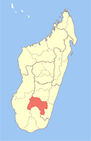 Location in Madagascar | |
| Country |
|
| Capital | Ihosy |
| Area[1] | |
| • Total | 26,391 km2 (10,190 sq mi) |
| Population (2013) | |
| • Total | 312,307 |
| • Density | 12/km2 (31/sq mi) |
| Time zone | UTC3 (EAT) |
Ihorombe is a region in Madagascar. It borders Haute Matsiatra region in north, Atsimo-Atsinanana in east, Anosy in south and Atsimo-Andrefana in west. The capital is Ihosy and the population was estimated to be 312,307 in 2013.[2] The area of Ihorombe is 26,391 km2 (10,190 sq mi) and it has one of the lowest population densities of the Malagasy regions.[1]
Administrative divisions
Ihorombe region is divided into three districts, which are sub-divided into 24 communes.
Protected Areas
References
- 1 2 Ralison, Eliane; Goossens, Frans. "Madagascar: Profil des marchés pour les évaluations d'urgence de la sécurité alimentaire" (PDF) (in French). Programme Alimentaire Mondial, Service de l’Evaluation des besoins d’urgence (ODAN). Archived from the original (PDF) on 2007-09-26. Retrieved 2008-03-01.
- ↑ Institut National de la Statistique, Abtananarivo.
Coordinates: 22°24′00″S 46°07′48″E / 22.40000°S 46.13000°E
This article is issued from
Wikipedia.
The text is licensed under Creative Commons - Attribution - Sharealike.
Additional terms may apply for the media files.