Idjwi
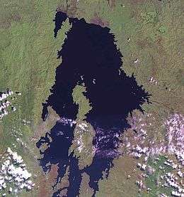 Idjwi, in the central-southern region of Lake Kivu | |
 Idjwi | |
| Geography | |
|---|---|
| Location | Lake Kivu |
| Coordinates | 2°09′57″S 29°03′22″E / 2.165851°S 29.056091°E |
| Area | 340 km2 (130 sq mi) |
| Length | 70 km (43 mi) |
| Highest point | Nyamusisi |
| Administration | |
|
Democratic Republic of the Congo | |
| Demographics | |
| Population | 250,000 (2009) |
| Pop. density | 700 /km2 (1,800 /sq mi) |
| Ethnic groups | Havu (Bany'Idjwi) |
Idjwi, or Ijwi, is an island in Lake Kivu belonging to the Democratic Republic of the Congo, in the Sud-Kivu province. At 70 km (43 mi) in length and with an area of 340 km2 (131 sq mi), it is the second largest inland island in Africa, and the tenth largest in the world.[1] Idjwi is roughly equidistant between the DRC and Rwanda, with 10 to 15 kilometres (6 to 9 mi) separating its western shore from the DRC mainland and a similar distance between its eastern shore and the coastline of Rwanda. The island's southern tip, however, lies only 1 kilometre from a promontory of the Rwandan coast.
History
Historically a clan-based Bahavu society, Idjwi island became a kingdom in the late 18th century (roughly between 1780 and 1840).[2]
Demographics
In 2013, the island was estimated to have a population of 252,000. This is a massive increase from the estimated population of 50,000 in 1983. Malnutrition is common, especially among children, and almost all of the population is dependent on subsistence agriculture.
References
- ↑ Retrieved 4 June 2007. Ukerewe Island in neighbouring Lake Victoria is considerably bigger than Idjwi, at 530 km2 (205 sq mi).
- ↑ Newbury, David S. (1991). Kings and Clans: Ijwi Island and the Lake Kivu Rift, 1780-1840. Univ of Wisconsin Press. p. 239. ISBN 9780299128944.
| Cities and communes |
| ||
|---|---|---|---|
| Territories | |||
| Populated places | |||
| Other | |||
Coordinates: 2°09′57″S 29°03′22″E / 2.165851°S 29.056091°E