IJmuiden
| IJmuiden | |
|---|---|
| City | |
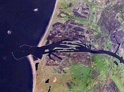 Satellite photo of IJmuiden and Velsen area | |
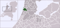 | |
 IJmuiden in the municipality of Velsen | |
| Coordinates: 52°27′31″N 4°37′10″E / 52.45861°N 4.61944°ECoordinates: 52°27′31″N 4°37′10″E / 52.45861°N 4.61944°E | |
| Country | Netherlands |
| Province | Noord-Holland |
| Municipality | Velsen |
| Population (2013) | |
| • Total | 30,160 |
| Time zone | UTC+1 (CET) |
| • Summer (DST) | UTC+2 (CEST) |
IJmuiden (Dutch pronunciation: [ˌɛi̯ˈmœy̯də(n)]) is a port city in the Dutch province of North Holland and is the main town in the municipality of Velsen. It is located at the mouth of the North Sea Canal to Amsterdam, and lies approximately 17 kilometres (11 mi) north of Haarlem.
The internal capitalization in the city's spelling is because IJ is a digraph in Dutch, and is therefore sometimes considered to be a ligature, rendering it a single letter.
The port of IJmuiden is a deepwater port suited to fully laden Panamax ships, and fourth port of the Netherlands.
History
In the Roman era, this Velsen district was already inhabited, and archaeological finds at the impoldered lake of Wijkermeer[1] indicate there was a North Sea port of some regional importance built here.[2] Present day IJmuiden includes four harbors: the vissershaven (Ship's code IJM), a fishing dock (visafslag), the haringhaven, the IJmondhaven and the Seaport Marina IJmuiden, a harbour for pleasure craft. IJmuiden became the largest fishing port of the Netherlands after the island of Urk became closed in by the Afsluitdijk. The town suffered heavy damage and demolition during World War II, because of its maritime importance.
Mouth of the IJ
Before the present IJmuiden was built, the area was known as Breesaap; it was a desolate plain where only a handful of farmers strove to make a living.
Plans to connect Amsterdam with a canal to the North Sea, with its mouth in this area, had been drawn up already since 1626, but were only set into motion in the 19th century, when in 1851 the whole area was sold to the entrepreneurs Bik and Arnold. The first spade hit the ground on 8 April 1865.
IJmuiden is the newest city in North Holland, and only came into existence on 1 November 1876, when the North Sea Canal was officially opened by William III of the Netherlands, connecting the Amsterdam harbours to the open sea. He dubbed the town "IJmuiden" after passing the locks from the North Sea into the canal. After his ship, the paddle steamer 'Stad Breda' built by the Stoomvaart Maatschappij Zeeland, passed, the first ship from Amsterdam, the 'SS Rembrandt' built by the Royal Netherlands Steamship Company (KNSM), passed the other way.[3] The workers who dug the canal later settled there; they found work after the canal was finished in the fishing industry, but many also suffered extreme poverty.
The IJmuiden name literally means “mouth of the IJ”, which is a hint to the importance the town has for the Amsterdam harbour. The name “IJmuiden” first appeared as IJ-muiden in lines written in 1848 by the professor and journalist (and, later, a liberal finance minister in the Van Lynden van Sandenburg Cabinet) Simon Vissering. The present IJmuiden form was eventually adopted in 1876, as the North Sea Canal was being completed in this section.
In 1890 it had about 1,500 inhabitants, but boomed when the Koninklijke Nederlandse Hoogovens steelworks settled in IJmuiden in 1918. At that time shipping was at a low, because during World War I minesweepers laid many mines off the coast of IJmuiden.[4] Also the canal mouth needed constant dredging due to the littoral drift in both directions on an open, sandy coast, due to winds blowing alternately from opposite quarters, sand accumulates in the sheltered angles outside the harbour between each converging breakwater and the shore.[5]
Second World War

After the German invasion of the Netherlands on 10 May 1940, the Dutch Royal family left the country from IJmuiden in the late evening of 12 May, some on board the British destroyer HMS Codrington, Queen Wilhelmina left on board HMS Hereward. The quays at IJmuiden were crowded at that time with people desperate to be transported across the channel, sometimes at great expense. During the German occupation, the canal was out of operation and the Germans destroyed most of IJmuiden to create what they called Festung IJmuiden (Fortress IJmuiden), a heavily defended area in which the entire civilian population had been removed.
IJmuiden became the site of two separate fortified pens constructed by the German navy (Kriegsmarine) to house their schnellboote (fast torpedo boats, known to the Allies as E-boats)[7] and Biber midget submarines.[8] The older structure, codename Schnellbootbunker AY (SBB1), was protected by a 10-foot (3.0 m) thick concrete roof.[7] The newer one, codename Schnellbootbunker BY (SBB2), had 10–12 feet (3.0–3.7 m) of concrete, with a further 2–4-foot (0.6–1.2 m) layer separated by an air–gap.[Note 1][8]
The E-boats laid up in the shelters during the day, safe from air–attack, and put to sea under cover of night to attack Allied shipping.[7] The pens were priority targets after D-day as the torpedo boats they protected were a considerable threat to the supply lines serving Allied forces in western Europe and were subjected to repeated air attack. This included four attacks by No. 9 Squadron and No. 617 Squadron of the Royal Air Force, during which a total of 53 of the five–ton, Tallboy earthquake bombs were dropped.[9][10] There were also two attacks in 1945 by the American air force with rocket–powered Disney bombs, specialist weapons designed to penetrate fortified, concrete bunkers that could resist conventional bombs.
The story of IJmuiden during the war is told in the Bunker Museum IJmuiden (in Dutch).
North Holland's gate to the North Sea

After the war, the town was rebuilt according to a plan by the architect Willem Marinus Dudok. The statistical area IJmuiden, which includes the surrounding countryside, has a population of 30,466. The headquarters of the KNRM, Royal Netherlands Sea Rescue Institution is located in IJmuiden. The IJmuiden harbour coast line remains the defining point for the equidistantly set UK-Netherlands sea boundary, regardless of expansions like Europoort.[11]
The North Sea Canal connects the North Sea with the IJ Bay in Amsterdam, and the importance of this ship canal has been recognized with the introduction of the "Holland Route" along the canal by the European Route of Industrial Heritage (ERIH). The places to see on this route are the Hoogovensmuseum, the system of sluice gates at the mouth of the canal, and the Zee- en Haven Museum in IJmuiden. IJmuiden is home to two of the world's most powerful water pumps capable of pumping 60,000 litres (13,000 imp gal; 16,000 US gal) per second.
Besides the Velsen Municipality Hall (Raadhuis van de gemeente Velsen), designed by the architect Willem Dudok as a centerpiece to his plan for a new IJmuiden, important sights in IJmuiden are the North Sea locks. The latter are among the largest in the world and one set is able to close off a shipping lane 50 metres (160 ft) wide and 12 metres (39 ft) deep. There are plans to enlarge or build a new set to facilitate passage for even larger vessels.
DFDS Seaways serve a route between Amsterdam and Newcastle via IJmuiden. A new roll-on/roll-off ferry route between IJmuiden and Great Yarmouth in the United Kingdom was considered.[12] Any plans in that direction appear to have been abandoned by the relevant authorities. A new initiative by Seamax Ferries to connect Great Yarmouth and IJmuiden by ferry is to start halfway 2018.[13]
The North Sea Race, is a yacht race which takes place annually. The event covers a distance of 210 nautical miles (390 km; 240 mi) and starts in Scarborough, North Yorkshire, in England and finishes in IJmuiden.
Gallery
 North Sea Canal's wide mouth
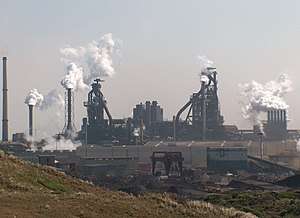 IJmuiden steelworks is a key actor for the IJ
 Fishing boats at quay in IJmuiden
 IJmuiden's marina
 Old water tower
Notes
- ↑ Only SBB2 has remained until today (52°27′36.72″N 4°34′39.08″E / 52.4602000°N 4.5775222°E).
References
- Citations
- ↑ http://www.cruise2holland.com/CityInformation/Beverwijk/Wijkermeerpolder.aspx
- ↑ "Archived copy". Archived from the original on 5 May 2012. Retrieved 28 April 2012.
- ↑ W. Moojen: '125 jaar Noordzeekanaal' in: 'DBW' jrg. 59 nr. 9 (2001)
- ↑

- ↑
- ↑ Combat bulletins CB n°57: Activities in ETO—Disney swish. Wikimedia Commons: US Army Pictorial Service. 1945.
- 1 2 3 Flower 2004, p. 203
- 1 2 Flower 2004, p. 301
- ↑ Flower 2004, Appendix A
- ↑ Bateman 2009, p. 92
- ↑ Lowe, Vaughan (1997). The United Kingdom and the law of the sea. Martinus Nijhoff. p. 549. ISBN 9041103260.
The UK-Netherlands .. boundary is notable because it uses the permanent harbour works at IJmuiden as part of the Dutch baselines, but was not modified to take account of the subsequent building of the Europoort facility on the Dutch coast.
- ↑ Dutch daily ferry link a step closer (Business Weekly, December 12, 2001) Archived 3 May 2008 at the Wayback Machine.
- ↑ Seamax homepage. Retrieved on 15-12-2017
- Bibliography
- Bateman, Alex (2009). Tony Holmes, ed. No 617 'Dambusters' Sqn. Oxford: Osprey. p. 111. ISBN 978-1-84603-429-9.
- Flower, Stephen (2004). Barnes Wallis' Bombs: Tallboy, Dambuster & Grand Slam. Stroud: Tempus. ISBN 9780752429878.
External links
