Hydrology of Switzerland
Hydrology is the science which studies the water cycle as a whole, hence the water exchanges between soil and atmosphere (precipitation and evaporation) but also between the soil and sub ground (groundwater).
Switzerland has a varied and complex hydrological system. The climate gives precipitation under the form of snow and rain and is also responsible for the evaporation of water into the atmosphere. The altitude and climate allow the formation and maintenance of many glaciers that feed rivers from five major European river catchments, through which water leaves the country and joins the sea.
Switzerland is sometimes called the "water tower of Europe".[1][2]
Surface water
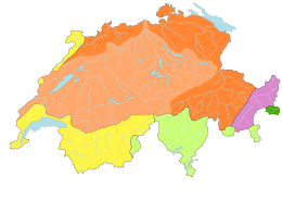
Surface water flows through a network of nearly 65,000 km of rivers, shared between the basins of five European rivers: the Rhine, the Rhone, the Po, the Danube and the Adige. Thus, the hydrological network of Switzerland brings feeds the North Sea, the Mediterranean Sea, the Adriatic Sea and the Black Sea. Among these five rivers, two have their source in Switzerland, the Rhine and the Rhone. The other three rivers have tributaries that originate in Switzerland.
All major lakes of Switzerland are located in the Rhine, Rhone and Po basins. Lakes in the Danube and Adige basins are less than 5 km².
| Basin | Percent of Swiss territory[3] | Major affluents in Switzerland | Largest lakes | Empties in |
|---|---|---|---|---|
| Rhine | 68 % | Aar, Reuss, Thur, Limmat | Lake Constance, Neuchâtel, Lucerne, Zurich | North Sea (in the Netherlands) |
| Rhone | 18 % | Doubs | Lake Geneva | Mediterranean Sea (in France) |
| Po | 9.3 % | Ticino | Lake Maggiore, Lugano | Adriatic Sea (in Italy) |
| Danube | 4.4 % | Inn | Lake Sils, Silvaplana | Black Sea (in Romania and Ukraine) |
| Adige | 0.3 % | Rom | Lai da Rims | Adriatic Sea (north of Po delta) |
Groundwater
Groundwater refers to water located beneath the ground surface, as opposed to surface water that forms lakes and rivers. This is called hydrogeology. The nature and location of the groundwater is defined by the geological nature of the soils. In the mid-twentieth century, knowledge of groundwater in Switzerland suffered from significant gaps. They were partially filled in the 1980s and 1990s, with a national research program.
The geological structure of Switzerland was formed by collision of two tectonic plates, the Eurasian plate to the north and the Adriatic plate to the south. Geologically, the subsoil is very complex and varied with the Alps in the south, the Jura in the northwest and the plateau between them. Large quantities of water are present in the basement of Switzerland, and form a vast network linked to the geological structures. The underground lake of Saint-Léonard, located in Valais, with its 300 m long and 25 m wide is a notable example.
Each year, one hectare of the Swiss plateau filter an average of four million liters of clean groundwater. According to the Federal Office of Environment, the Swiss basement contains about fifty billion m3 of water. Groundwater is by far the main source of drinking water in Switzerland, covering 80% of requirements. Considering other uses (drinking water and industrial water), groundwater covers 58% of requirements.
See also
References
- ↑ Eine grosse Verantwortung für das "Wasserschloss Europas" bafu.admin.ch. Retrieved 2011-04-12
- ↑ Viviroli, Daniel; Weingartner, Rolf (2004). "The Hydrological Significance of the European Alps". Hydrological Atlas of Switzerland. Federal Office for the Environment. ISBN 978-3-95202620-5. Archived from the original on 2015-01-20. Retrieved 2014-09-04.
- ↑ Oskar Bär, Geographie der Schweiz, p. 33, 1973
- The Hydrology of Switzerland admin.ch