Hurst, North Yorkshire

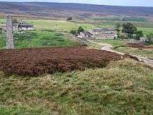
Hurst is a secluded hamlet in North Yorkshire, England about ten miles north-west of Richmond.[1] It lies on a road which it shares with another hamlet, Washfold. Hurst was a mining centre in the 19th century,[2] but there is evidence that the Romans also produced lead here.
References
- ↑ Ordnance Survey: Landranger map sheet 92 Barnard Castle & Richmond (Teesdale) (Map). Ordnance Survey. 2011. ISBN 9780319228982.
- ↑ Tyson, L.O. (1983). The Hurst Mining Field, Yorkshire (PDF). The Northern Mine Research Society Sheffield U.K. pp. 61–77. Retrieved 4 April 2016.
This article is issued from
Wikipedia.
The text is licensed under Creative Commons - Attribution - Sharealike.
Additional terms may apply for the media files.