Hurdegaryp
| Hurdegaryp Hardegarijp | |||
|---|---|---|---|
| Village | |||
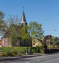 Hurdegaryp, church (de Hofkerk) | |||
| |||
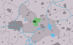 Location of the village in Tytsjerksteradiel | |||
 Hurdegaryp Location in the Netherlands | |||
| Coordinates: Coordinates: 53°12′54″N 5°56′25″E / 53.21500°N 5.94028°E | |||
| Country |
| ||
| Province |
| ||
| Municipality |
| ||
| Population (1 January 2017) | |||
| • Total | 4,788 | ||
| Time zone | UTC+1 (CET) | ||
| • Summer (DST) | UTC+2 (CEST) | ||
| Postal code | 9254 | ||
| Dialing code | 0511 | ||


Hurdegaryp (Dutch: Hardegarijp) is a village in the northern part of the Netherlands, in the municipality of Tytsjerksteradiel. Its history dates back to at least the 13th century. It had a population of around 4,788 in January 2017.[1]
In Dutch the village is called Hardegarijp, Hurdegaryp is its West Frisian and official name.
Transportation
See also
References
- ↑ Overzicht inwonersaantal Tytsjerksteradiel - Tytsjerksteradiel
| Administrative Centre |  | |
|---|---|---|
| Villages | ||
| Hamlets | ||
| Landmarks | ||
| Lakes |
| |
| Authority control |
|---|
This article is issued from
Wikipedia.
The text is licensed under Creative Commons - Attribution - Sharealike.
Additional terms may apply for the media files.