Huntley Street
Huntley Street is a street in Bloomsbury, London, known for its close association with University College Hospital.
Location
Huntley Street runs from Grafton Way in the north to Chenies Street in the south. It runs parallel with Tottenham Court Road and Gower Street. It is crossed by University Street and Torrington Place. Capper Street and Chenies Mews join it halfway down.
Character
The southern part of the street is dominated by residential mansion blocks while the northern part of the street has more commercial and hospital buildings. The Marlborough Arms public house is on the corner with Torrington Place and The Jeremy Bentham on the corner with University Street.
Hospital buildings
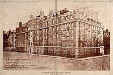
The northern part of the street is dominated by buildings related to University College Hospital (UCH). The rear of the UCH Cruciform Building is on the corner of the street with Grafton Way. Opposite is the Rosenheim Building and further down the street on the same side is the UCH Macmillan Cancer Centre. The Paul O'Gorman Building is on the east side and a new building was announced in October 2014 for the western side of the street.[2]
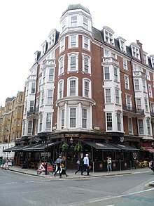
Chenies Street Chambers
At the southern end on the western side is Chenies Street Chambers which once had its entrance in Chenies Street. Following bombing during the Second World War, the main entrance to the building is now in Huntley Street.[3] The building was originally designed as flats for single professional women, but is now social housing.[4]
External link
Part of Horwood's Plan, showing Upper Thornhaugh Street, before it was lengthened (and re-named Huntley Street in the 1830s).
References
- ↑ V0013634. Wellcome Images. Retrieved 2 January 2015.
- ↑ Plans for new hospital in Huntley Street to be shown at forum. Fitzrovia News, 7 October 2014. Retrieved 31 January 2014.
- ↑ Metropolitan Borough of Camden Record of AIR RAID INCIDENTS. Chenies Street Chambers Historical Society. Retrieved 31 December 2014.
- ↑ CHENIES STREET CHAMBERS. Chenies Street Chambers Historical Society. Retrieved 31 December 2014.
Coordinates: 51°31′19.33″N 0°8′1.21″W / 51.5220361°N 0.1336694°W