Hung Hom
| Hung Hom | |||||||||||||||||
| Traditional Chinese | 紅磡 | ||||||||||||||||
|---|---|---|---|---|---|---|---|---|---|---|---|---|---|---|---|---|---|
| Simplified Chinese | 红磡 | ||||||||||||||||
| Cantonese Yale | Hùhngham | ||||||||||||||||
| Literal meaning | "Red Cliff" | ||||||||||||||||
| |||||||||||||||||
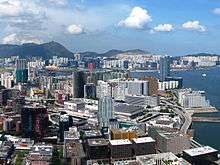


Hung Hom (Cantonese pronunciation: [hȍŋ hɐ̄m]) is an area of Kowloon, in Hong Kong, administratively part of the Kowloon City District, with a portion west of the railway in the Yau Tsim Mong District (油尖旺區). Hung Hom serves mainly residential purposes though is mixed with some industrial buildings in the north.
Geography
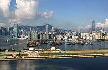
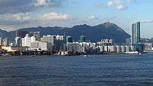
Hung Hom is in the southeast of the Kowloon Peninsula. It is bordered by Victoria Harbour in the south, King's Park in the west, Hung Hom Bay in the east, No. 12 Hill, Hok Yuen and the valley Lo Lung Hang. in the north.
History
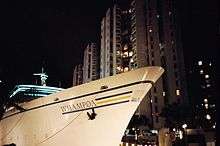
Originally, Hung Hom was much smaller than the present-day context. Hung Hom Bay has been partially reclaimed several times since 1850, expanding the area of Hung Hom as a consequence. Rumsey Rock, formerly located in the bay, was buried in the reclamation process. Later a town was developed eastward parallel to the Hong Kong and Whampoa Dock.
Hung Hom was renamed to "Yamashita District" during the Japanese occupation from 1941 to 1945.[1] It was one of the few places to be renamed.
Demographics
There is a large Japanese residence community in Hung Hom due to the established JUSCO Japanese-style department store in Whampoa Garden. There is also a growing number of other foreign residents, like Koreans, Indians, etc.
Education
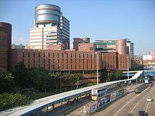
- Hong Kong Polytechnic University
- Hong Kong Community College (Hung Hom Bay campus)
- Holy Carpenter Secondary School
- Lycée Français International Victor Segalen (French international school)
- The Hung Hom Campus houses primary school students; it opened in September 2014.[2]
- Holy Angels Canossian School
Housing
- Harbour Place
- Harbourfront Horizon
- Harbourview Horizon
- The Harbourfront Landmark
- Hunghom Bay Centre
- Laguna Verde
- The Metropolis Residence
- Royal Peninsula
- Stars by the Harbour
- Whampoa Garden
- Public housing estates in Hung Hom
Facilities
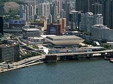
- Hong Kong Coliseum
- Tai Wan Shan Swimming Pool
- Hung Hom Municipal Building, which includes the Hung Hom Library, Hung Hom Municipal Building Sports Centre, and the Hung Hom Market with a cooked food centre
- Hung Hom Fire Station
- Two post offices and the International Mail Centre
- Hutchison Park. A small park located in a built up residential area once occupied by docklands and fill-in to create more land for residential use.
- Tai Wan Shan Park
- Hong Kong Police Traffic Kowloon West Base
- Hung Hom Clinic
- Several malls in Whampoa Garden
- Lux Theatre
- Hotels, including Harbour Grand Kowloon and Harbour Plaza Metropolis
Religion
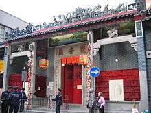
- Kwun Yum Temple. Built in 1873.[3] Grade II historic building
- Pak Tai Temple, located at No. 146 Ma Tau Wai Road. Built in 1876.[4] Grade III historic building
- Holy Carpenter Church (Anglican)
- St. Mary's Church (Catholic)
- True World Lutheran Church
Transport
MTR
Hung Hom is served by the Hung Hom Station of the MTR. The station serves as the southern terminus of both East Rail Line and West Rail Line, as well as the terminus of cross-border services with destinations to major cities in China.
As of October 2016, Ho Man Tin Station and Whampoa Station as part of an extension of the Kwun Tong Line, are available for accessing the Hung Hom area.
Tunnel
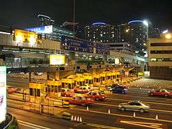
The Cross-Harbour Tunnel was the first tunnel in Hong Kong that was built under water. It connects Hong Kong Island and Kowloon at respectively Kellett Island (now connected to Hong Kong Island) and a reclaimed site at Hung Hom Bay.
Ferries
Ferries serving Hung Hom Ferry Pier:
- New World First Ferry: North Point Ferry Pier - Hung Hom Ferry Pier (HK$6.5)
- Star Ferry: ceased services to Central Pier and Wan Chai Pier, effective 1 April 2011
Buses
There are three bus terminals in Hung Hom. Many buses serve the area.
- Solely-operated cross harbour route: 108
- Cross harbour routes operated with Citybus: 102, 102P, 102R, 103, 107, 107P, 117, 118, 118P, 170, 171, 182
- Cross harbour routes operated with New World First Bus: 101, 101R, 104, 106, 106P, 109, 110, 111, 112, 113, 115, 115P, 116, 301, 802, 811, N121;
- Non-cross harbour routes: 2E, 3B, 5, 5A, 5C, 5D, 6C, 6F, 7B, 8, 8A, 8P, 11, 11K, 11X, 12A, 13X, 14, 15, 21, 26, 28, 30X, 41, 45, 85C, 85X, 85S, 93K, 98D, 212, 219X, 219P, 224X, 230X, 260A, 260X, 268B, 269B, 296D, 297, N216, N241, N281;
- New World First Bus: 796X.
- Citybus:A22, E23, R22, R11, N11, N23.
- Minibus routes: 2, 2A, 6, 6A, 6X, 8, 13.
See also
References
- ↑ Philip Snow: The Fall of Hong Kong. 2003. ISBN 0300093527 page 159
- ↑ "Campuses - Hung Hom." Lycée Français International Victor Segalen. Retrieved on 25 January 2015. "68 Gillies Avenue South, Hung Hom, Hong Kong"
- ↑ Chinese Temples Committee: Kwun Yum Temple, Hung Hom
- ↑ Chinese Temples Committee: Pak Tai Temple, Hok Un Kok
External links
| Wikimedia Commons has media related to Hung Hom. |
Coordinates: 22°18′14″N 114°10′59″E / 22.30383°N 114.18297°E