Hundwiler Höhi
| Hundwiler Höhi | |
|---|---|
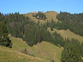 View from the south side | |
| Highest point | |
| Elevation | 1,306 m (4,285 ft) |
| Prominence | 406 m (1,332 ft) [1] |
| Isolation | 4.6 kilometres (2.9 mi) |
| Parent peak | Säntis |
| Coordinates | 47°20′27″N 9°20′00″E / 47.34083°N 9.33333°ECoordinates: 47°20′27″N 9°20′00″E / 47.34083°N 9.33333°E |
| Geography | |
 Hundwiler Höhi Location in Switzerland | |
| Location | Appenzell Ausserrhoden/Appenzell Innerrhoden, Switzerland |
| Parent range | Appenzell Alps |
The Hundwiler Höhi (1,306 m) is a mountain of the Appenzell Alps, located on the border between the Swiss cantons of Appenzell Ausserrhoden and Appenzell Innerrhoden. It is situated between Hundwil and Gonten.
The summit is easily accessible from every side of the mountain and is a popular vantage point over the Säntis, the Alpstein massif and Lake Constance. A mountain hut is located near the top.
References
External links

- Hundwiler Höhi on Hikr
This article is issued from
Wikipedia.
The text is licensed under Creative Commons - Attribution - Sharealike.
Additional terms may apply for the media files.