Hundsheimer Berge
| Hundsheimer Berge | |
|---|---|
 Hundsheimer Berge | |
| Highest point | |
| Peak | Hundsheimer Berg |
| Elevation | 481 m (1,578 ft) |
| Coordinates | 48°07′57″N 16°56′18″E / 48.13250°N 16.93833°E |
| Geography | |
| Country | Austria |
| Range coordinates | 48°07′N 16°58′E / 48.117°N 16.967°ECoordinates: 48°07′N 16°58′E / 48.117°N 16.967°E |
| Parent range | Western Carpathians |
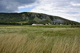
The Hundsheimer Berge (also Hainburger Berge) is a hill range located in Lower Austria and Burgenland, Austria next to the Devín Gate. It is the most southern part of the Devín Carpathians. The mountain range covers approximately 36 km2 and is bordered by the river Danube to the north and east, and the Vienna plate to the south and west. Its highest peak is Hundsheimer Berg (481 meters AMSL). While fairy low, the Hundsheimer Berge rise from only 140 meters above sea level by the Danube.[1]
The mountains are densely forested, mostly with beech trees. The southern slopes are traditionally used by humans for agriculture and particularly wine-making. There are many vineyards in the area. South of Edelstal are wine cellars offering wine-tasting. The mountains feature the ruins of the Pottenburg Castle.
Major peaks:
External links
| Wikimedia Commons has media related to Hundsheimer Berge. |
References
- ↑ "Hainburgské vrchy, Rakouské Karpaty (Hainburger Berge, Austrian Carpathians". Karpaty.net. Retrieved 11 August 2012.