Hundred of Wallaroo
| Wallaroo South Australia | |||||||||||||||
|---|---|---|---|---|---|---|---|---|---|---|---|---|---|---|---|
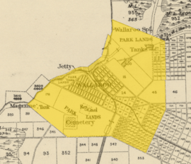 1874 boundaries of Wallaroo Town shown on an excerpt of an 1888 map of the hundred | |||||||||||||||
 Wallaroo | |||||||||||||||
| Coordinates | 33°59′42″S 138°39′07″E / 33.995°S 138.652°ECoordinates: 33°59′42″S 138°39′07″E / 33.995°S 138.652°E | ||||||||||||||
| Established | 12 June 1862 | ||||||||||||||
| Area | 320 km2 (124 sq mi) | ||||||||||||||
| LGA(s) | Copper Coast | ||||||||||||||
| Region | Yorke Peninsula | ||||||||||||||
| County | Daly | ||||||||||||||
| |||||||||||||||
The Hundred of Wallaroo is a cadastral unit of hundred located on the Copper Coast of South Australia.[1] It is one of the 16 hundreds of the County of Daly.[2] It was named in 1869 by Governor Dominick Daly[1] after an indigenous term presumed to mean wallaby urine.[1]
Locations
.jpg)
Map of the hundred in 1912
The most densely populated town and localities of the Copper Coast council are situated inside (or largely inside) the bounds of the Hundred of Wallaroo:
- Wallaroo and North Beach
- Kadina (western half) and its suburbs: New Town, Jericho, Wallaroo Mines, Matta Flat and Jerusalem
- Moonta and its suburbs: Moonta Bay, North Moonta, Paramatta, Cross Roads, North Yelta, Yelta, Moonta Mines, East Moonta, Hamley, Port Hughes and Kooroona
- Rural localities of Wallaroo Plain (west portion), Warburto and Boors Plain (larger west portion)
Local government
- Corporate Town of Kadina (1872-1977)
- Corporate Town of Moonta (1872-1984)
- Corporate Town of Wallaroo (1874-1997)
- District Council of Kadina (1888-1984)
- District Council of Northern Yorke Peninsula (1984-1997)
- District Council of the Copper Coast (1997-)
See also
References
- 1 2 3 "Search for 'Hundred of Wallaroo, HD'". Land Services, Government of South Australia. SA0016834. Retrieved 5 July 2017.
Derivation of Name: Corruption of Abna wadla warru; Other Details: Area 124 square miles. Wadla warru means wallaby's urine twisted to wallawaroo then to wallaroo.
- ↑ South Australia hundred maps 1:63 360. Surveyor General's Office. 1867.
This article is issued from
Wikipedia.
The text is licensed under Creative Commons - Attribution - Sharealike.
Additional terms may apply for the media files.