Humboldt Peak (Nevada)
| Humboldt Peak | |
|---|---|
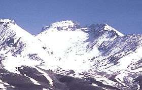 Humboldt Peak, looking north | |
| Highest point | |
| Elevation | 11,025 ft (3,360 m) NAVD 88[1] |
| Prominence | 860 ft (262 m) [2] |
| Coordinates | 40°54′05″N 115°07′11″W / 40.901309164°N 115.119702292°WCoordinates: 40°54′05″N 115°07′11″W / 40.901309164°N 115.119702292°W [1] |
| Geography | |
 Humboldt Peak | |
| Parent range | East Humboldt Range |
| Topo map | USGS Humboldt Peak |
| Climbing | |
| Easiest route | From ridge above Steele Lake: Hike & Scramble |
Humboldt Peak is the southernmost high summit in the East Humboldt Range of Elko County in northeastern Nevada. To the west are First and Second Boulder Canyons, to the south is Pole Canyon and Secret Pass, and to the east is the South Fork of Steele Creek and Clover Valley. The summit is the end of a high crest running almost 10 miles (16 km) to the north, and the beginning of a slow descent to Ruby Valley to the southeast. The summit, the fourth highest peak in the range, is located about 16 miles (26 km) southwest of the community of Wells. The mountain is in the East Humboldt Wilderness and Humboldt National Forest.
References
- 1 2 "Humboldt". NGS data sheet. U.S. National Geodetic Survey. Retrieved 2008-04-04.
- ↑ "Humboldt Peak, Nevada". Peakbagger.com. Retrieved 2011-05-18.
External links
- "Humboldt Peak". Geographic Names Information System. United States Geological Survey. Retrieved 2008-04-04.
This article is issued from
Wikipedia.
The text is licensed under Creative Commons - Attribution - Sharealike.
Additional terms may apply for the media files.