Hukeri
| Hukkeri | |
|---|---|
| Town | |
 Hukkeri Location in Karnataka, India | |
| Coordinates: 16°14′N 74°36′E / 16.23°N 74.6°ECoordinates: 16°14′N 74°36′E / 16.23°N 74.6°E | |
| Country |
|
| State | Karnataka |
| District | Belagavi |
| Elevation | 631 m (2,070 ft) |
| Population (2011) | |
| • Total | 23,010 |
| Languages | |
| • Official | Kannada |
| Time zone | UTC+5:30 (IST) |
| PIN | 591309 |
| Telephone code | 08333 |
| Vehicle registration | KA-49 |
Hukkeri is a Town Municipal Council and taluka in Belagavi district in the Indian state of Karnataka.[1]
Geography
Hukkeri is located at 16°14′N 74°36′E / 16.23°N 74.6°E.[2]
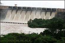
It is 50 km from Belagavi on north direction. About the Transportation – Nearest Airport – Belagavi 50 km. Nearest Railway stations – Belagavi 50 km, Ghataprabha – 18 km River – Hiranyakesi, Near Factories – Hira Sugar Factory,Sangam Sugar Factory, Vishwanath Sugar Factory, Nearby picknic spots – Gokak falls, Hidkal Dam, Gudachana malaki falls, Schools and Colleges – Hukkeri has good schools in different medium like Kannada, Urdu, and English. It has Arts, Commerce, Science. It has nearby Engineering and Diploma colleges in Nidasoshi.
Hukkeri is a name which is derived from two words 'hoovina' + 'kere' means it was a place where plenty of flowers were grown and were supplied to Adilshah of Bijapur.
There are 3 GolGumbaz's are located at middle of the town Hukkeri. One is used as PWD IB and other 2 are just left. Agriculture is the major occupation. Major crops are cotton, ground nut, sugar cane and maize. For higher education most of the students study Social Work. Local temples include Shree Prabhudevar, Shree Mallikarjun, Shree Lakshmidevi, Shree Siddharood, Shree Brahmadevar, Shree Duradundeshwar, Shree Hanuman and Shree Veerabhadreswar.
Demographics
As of 2001 India census,[3] Hukkeri had a population of 19,906. Males constitute 51% of the population and females 49%. Hukkeri has an average literacy rate of 63%, higher than the national average of 59.5%: male literacy is 72%, and female literacy is 55%. In Hukkeri, 14% of the population is under 6 years of age.
Villages under Hukkeri Taluk
Hukkeri Rural Electric Co-operative Society Ltd (HRECS)
The Hukkeri Rural Electric Co-Operative Society Ltd is the First Rural Electric Co-operative Society to be registered in India. Hukkeri Society is one of the last surviving epitomes of the co-operative movement in India.. The Society is daring all odds as amidst 74% IP set consumption, the highest ever for any distribution areas in the state, without receiving any subsidy from the Government. Whole of Hukkeri Taluk and some villages of Belgaum, Gokak and Chikkodi taluks are serviced by Hukkeri Rural Electricity Co-operative Society. HRECS covers an area of 30.00 sq km, with a population of over 4Lacs. The organization has five zones which are called as
- Hukkeri (East)
- Hukkeri (West)
- Sankeshwar
- Yamakanmardi
- Hidkal Dam
Hukkeri Society is the only Rural Electric Cooperative Society in the state of Karnataka serving about 83,000 consumers in Hukkeri, Taluka,Sutagatti and Maranahole villages of Belgaum taluk, Kamatyanatti of Chikkodi taluk and water supply works of Mallapur village in Gokak taluk. The organization was formed as a co-operative society under the Karnataka Co-operative Societies Act, 1959 as one of the five pilot Rural Electric Co-operative Societies (RECS) established on 21-07-1969 through Rural Electrification Corporation Limited (REC), New Delhi, as per the decision of Government of India and based on sponsorship from United States Agency for International Development (USAID) in collaboration with National Rural Electric Cooperative Association (NRECA), of the United States of America. Initially, the Government of Karnataka (GoK) granted the license for distribution of electricity to the Society on 12-10-1970. Since then, the Society is engaged in the distribution of electricity to Hukkeri Taluk. Thereafter, Karnataka Electric Regulatory Commission (KERC) was constituted under the Karnataka Electricity Reforms Act, 1999. The Society was granted the license initially for a period of five years, in October, 2001 thereafter, KERC, by its order No L/1/06 dated 14 November 2006 for a period of twenty five (25) years from 19 October 2006
Vallabhgad
Vallabhgad Fort is a fort in the Belgaum district of Karnataka state, India. It dates back to 1674, and is said to have been built by the Maratha ruler Shivaji. SAAMANGAD: This fort has fables woven around it. Situated in the Gadhinglaj taluka the fort has secret passages and bastions. PAARGAD: Surrounded by a forest, the fort has bronze statues of Shivaji and a temple of Bhagawati Bhawani. KALANIDHIGAD: Is said to have been built by the Maratha ruler Shivaji. BHUDARGAD: This fort is situated on a huge vertical rock amidst mountain ranges. It is said to resemble from a distance, the crescent moon in the matted hair of the god Shiva.. RAMTEERTH: A picnic spot in Ajra taluka, with ancient temples, a river, an old coffee plantation and an orchard. According to legend, the place is so named because Rama stayed here during his vanvaas or exile in the forest. AMBOLI: Situated in the southern ranges of the Sahyadri hills, Amboli at an altitude of 690 m is the last mountain resort before the coastal highlands.
References
- ↑ "Reports of National Panchayat Directory: Village Panchayat Names of Hukeri, Belgaum, Karnataka". Ministry of Panchayati Raj, Government of India. Archived from the original on 13 November 2011.
- ↑ Falling Rain Genomics, Inc – Hukkeri
- ↑ "Census of India 2001: Data from the 2001 Census, including cities, villages and towns (Provisional)". Census Commission of India. Archived from the original on 2004-06-16. Retrieved 2008-11-01.