Huisduinen
| Huisduinen | |
|---|---|
| Village | |
 Huisduinen | |
 | |
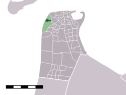 The village centre (darkgreen) and the statistical district (lightgreen) of Huisduinen in the municipality of Den Helder. | |
| Coordinates: 52°57′8″N 4°43′34″E / 52.95222°N 4.72611°ECoordinates: 52°57′8″N 4°43′34″E / 52.95222°N 4.72611°E | |
| Country | Netherlands |
| Province | Noord-Holland |
| Municipality | Den Helder |
| Elevation | 0 m (0 ft) |
| Population (2001) | |
| • Total | 513 |
| Time zone | UTC+1 (CET) |
| • Summer (DST) | UTC+2 (CEST) |
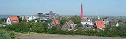
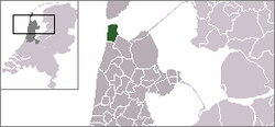
Huisduinen (Dutch pronunciation: [ˈɦœyzdœynə(n)]) is a village in the Dutch province of North Holland. It is a part of the municipality of Den Helder, and lies about 2 km west of Den Helder.
In 2001, the village of Huisduinen had 513 inhabitants. The built-up area of the village was 0.18 km², and contained 231 residences.[1] The statistical district "Huisduinen", which covers the village and the surrounding countryside, has a population of around 520.[2]
The fortress Kijkduin was built by Napoleon in Huisduinen. In Dutch, the Battle of Texel (1672) is named "Battle of Kijkduin" after this location.
References
This article is issued from
Wikipedia.
The text is licensed under Creative Commons - Attribution - Sharealike.
Additional terms may apply for the media files.