Huia, New Zealand
| Huia | |
|---|---|
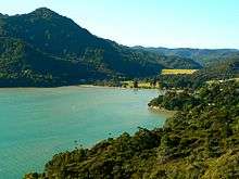 Looking North-West over the lower Huia dam. | |
| Basic information | |
| Local authority | Auckland Council |
| Surrounds | |
| North | (Waitakere Ranges) |
| Northeast | Woodlands Park |
| East | (Parau) |
| Southeast | (Manukau Harbour) |
| South | (Manukau Harbour) |
| Southwest | (Manukau Heads) |
| West | Little Huia |
| Northwest | (Waitakere Ranges) |
Huia is a western rural/coastal settlement of Waitakere City, Auckland, New Zealand and forms part of the Waitakere Ranges Regional Park. The approximate population is 580.
Huia was originally known as Te Huia as the area is thought to be named after a Māori chief, Te Huia, who stayed in the bay and was so taken by the area that he remained there.[1][2] The English translation "The Huia" was used into the 1970s, but simply "Huia" has now become more commonplace.[3]
The majority of houses in Huia are located along Huia Road, which arcs around Huia Bay and heads west towards Little Huia.
Huia has a single store/cafe (Huia Store), which celebrated its 120th anniversary in 2006.[4] Huia is also served by the Huia Volunteer Fire Brigade.
On the shores of Huia Bay is Huia Reserve, there are picnic tables, a BBQ, a small playground, basketball half-court and a half pipe for skating. It is close to the Lower Huia Dam Track.
The Upper Huia Dam opened in 1929 and the Lower Huia Dam opened in 1971. Both reservoirs form part of the water supply for Auckland.
The Auckland Council operates several accommodation facilities in the area including the Kiwanis Huia camp, Huia Lodge (which comprises the old school building), Barr cottage (situated on the waterfront in LIttle Huia) and a camping area known as Barn Paddock in the Karamatura farm.[5]
Huia Settlers Museum is located near the entrance to the Karamatura Park. The museum contains many relics of the Kauri felling and milling and artefacts from the wreck of HMS Orpheus.
Old Huia School is past the museum. The school opened in 1894 and closed in 1961 due to dwindling numbers. It is now Huia Lodge. The local state secondary school is Green Bay High School.
There are an abundance of walking tracks around the Huia area and there are numerous camp sites in the Karamatura Valley. The highest point in the Waitakere Ranges - Te Toi o Kawharu (474m) [accessible via the Twin Peaks Track] is part of this valley.
References
| Wikimedia Commons has media related to Huia (suburb). |
- ↑ Laing, N. (1985). "The settlement of the Huia: a history of the Huia and adjacent parts of the Manukau Harbour", Auckland.
- ↑ Reed, A.W. (2002). The Reed Dictionary of New Zealand place names, Reed Publishing, Auckland. ISBN 978-0-7900-0040-4.
- ↑ Laing, N. (1976). "Huia: an album from the past", Lodestar Press, Auckland.
- ↑ "Huia: Big adventure, little time". The New Zealand Herald. 30 March 2009. Retrieved 7 January 2012.
- ↑ "Our Parks: Huia". arc.govt.nz. Retrieved 5 June 2008.
External links
- Photographs of Huia held in Auckland Libraries' heritage collections.