Huglo
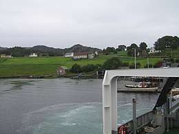 View of Huglo, from the ferry | |
 Location in Hordaland county | |
| Geography | |
|---|---|
| Location | Hordaland, Norway |
| Coordinates | 59°51′03″N 5°35′06″E / 59.8508°N 5.5850°ECoordinates: 59°51′03″N 5°35′06″E / 59.8508°N 5.5850°E |
| Area | 13.5 km2 (5.2 sq mi) |
| Length | 6.9 km (4.29 mi) |
| Width | 3.8 km (2.36 mi) |
| Highest elevation | 218 m (715 ft) |
| Highest point | Høgafjellet |
| Administration | |
| County | Hordaland |
| Municipality | Stord |
Huglo is an island in Stord municipality in Hordaland county, Norway. The 13.5-square-kilometre (5.2 sq mi) island lies in the Hardangerfjorden, just east of the large island of Stord and just south of Tysnesøy. The small island of Skorpo lies immediately northeast of this island. The highest point on the rugged island is the 218-metre (715 ft) tall Høgafjellet.[1]
The island of Huglo has no road connections off of the island other than the regular car ferry routes connecting to Stord and Tysnesøy islands. There are about 100 inhabitants there and the main industries are farming and the making of furniture and customized golf clubs.
See also
References
- ↑ Store norske leksikon. "Huglo" (in Norwegian). Retrieved 2015-02-03.
This article is issued from
Wikipedia.
The text is licensed under Creative Commons - Attribution - Sharealike.
Additional terms may apply for the media files.