Huamashraju
| Huamashraju | |
|---|---|
| Yanahuacra, Rajo Colta | |
 | |
| Highest point | |
| Elevation | 5,434 m (17,828 ft) |
| Coordinates | 9°31′30″S 77°23′06″W / 9.52500°S 77.38500°WCoordinates: 9°31′30″S 77°23′06″W / 9.52500°S 77.38500°W |
| Geography | |
 Huamashraju Peru | |
| Location | Peru, Ancash Region |
| Parent range | Andes, Cordillera Blanca |
| Climbing | |
| First ascent | 1954, J. Cabana and A. Soriano[1] |
Huamashraju,[2][3][1] Wamashraju,[4] (possibly from Quechua rahu snow, ice, mountain with snow),[5] Yanahuacra[3] (possibly from Quechua yana black, waqra horn, "black horn") or Rajo Colta[6] is a mountain in the Cordillera Blanca in the Andes of Peru, about 5,434 metres (17,828 ft) high.[2][3][6] It is situated in the Ancash Region, Huaraz Province, Huaraz District. Huamashraju lies east of the town of Huaraz, west of Huantsán and northwest of Shacsha and Cashan.
Gallery
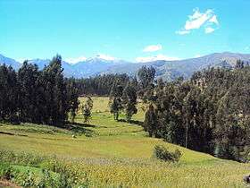
 Huamashraju as seen from Huaraz
 Ranrapalca (in the distance), Rima Rima, Churup (middle, left), Collapaco and Huamashraju as seen from Huaraz
 Ranrapalca (on the left), Huamashraju, Cashan, Shacsha (center) and Huantsán (on the right) as seen from the southwest
See also
References
- 1 2 "Huamashraju". www.montanasperuanas.com. Retrieved 2016-06-22.
- 1 2 Alpenvereinskarte 0/3b. Cordillera Blanca Süd (Peru). 1:100 000. Oesterreichischer Alpenverein. 2005. ISBN 3-937530-05-3.
- 1 2 3 Neate, Jill (1994). "Peru". Mountaineering in the Andes (PDF). RGS-IBG Expedition Advisory Centre. p. 14. ISBN 0-907649-64-5.
- ↑ Ricker, John (1977). Yuraq Janka: A Guide to the Peruvian Andes. The Mountaineers Books. pp. 109–111.
- ↑ babylon.com
- 1 2 Peru 1:100 000, Recuay (20-i). IGN (Instituto Geográfico Nacional - Perú).
This article is issued from
Wikipedia.
The text is licensed under Creative Commons - Attribution - Sharealike.
Additional terms may apply for the media files.