Huahine – Fare Airport
| Huahine – Fare Airport | |||||||||||
|---|---|---|---|---|---|---|---|---|---|---|---|
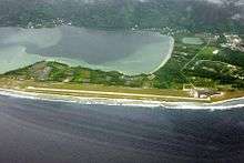 Huahine – Fare Airport from above, in 2009. | |||||||||||
| Summary | |||||||||||
| Location | Huahine, French Polynesia | ||||||||||
| Coordinates | 16°41′14″S 151°1′18″W / 16.68722°S 151.02167°WCoordinates: 16°41′14″S 151°1′18″W / 16.68722°S 151.02167°W | ||||||||||
| Map | |||||||||||
 NTTH Location within French Polynesia | |||||||||||
| Runways | |||||||||||
| |||||||||||
|
Sources: WorldAeroData[1] | |||||||||||
Huahine – Fare Airport is an airport serving the island of Huahine in French Polynesia (IATA: HUH, ICAO: NTTH). The airport is located in the northern part of the commune of Fare, on the Island of Huahine Fare, French Polynesia.[2]
In 2006, 151,907 passengers used the airport.[3]
Airlines and destinations
| Airlines | Destinations |
|---|---|
| Air Tahiti | Bora Bora, Moorea, Papeete, Raiatea |
References
- ↑ "Huahine". WorldAeroData. WorldAeroData. Retrieved 27 July 2011.
- ↑ http://www.tahiti-aeroport.pf/articles.php?cat=8
- ↑ http://www.aeroport.fr/les-aeroports-de-l-uaf/stats-huahine.php
External links
- Huahine-Fare Airport
- NTTH – HUAHINE. AIP from French Service d'information aéronautique, effective 11 October 2018.
This article is issued from
Wikipedia.
The text is licensed under Creative Commons - Attribution - Sharealike.
Additional terms may apply for the media files.