Hrafnagil
| Hrafnagil | |
|---|---|
| Village | |
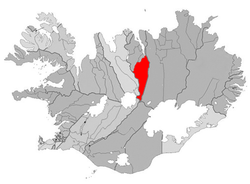 Location of the Municipality of Eyjafjarðarsveit | |
 Hrafnagil Location of Hrafnagil | |
| Coordinates: 65°34′20″N 18°5′40″W / 65.57222°N 18.09444°WCoordinates: 65°34′20″N 18°5′40″W / 65.57222°N 18.09444°W | |
| Country |
|
| Constituency[1] | Northeast Constituency |
| Region[2] | Northeastern Region |
| Municipality | Eyjafjarðarsveit |
| Population (2016) | |
| • Total | 260 |
| Postal code | 601 |
| Website | Official website |
Hrafnagil (also known as Reykárhverfi) is a small village in Eyjafjarðarsveit, northern Iceland, which in 2016 had 260 inhabitants.
In the village is a school and a community center. In the area, geothermal heat can be found and is used to heat houses and greenhouses.
References
This article is issued from
Wikipedia.
The text is licensed under Creative Commons - Attribution - Sharealike.
Additional terms may apply for the media files.