Horsetrough Falls
| Horsetrough Falls | |
|---|---|
 | |
| Location | Union County, Georgia |
| Coordinates | 34°47′32″N 83°47′14″W / 34.792167°N 83.787333°WCoordinates: 34°47′32″N 83°47′14″W / 34.792167°N 83.787333°W |
| Type | Cascade |
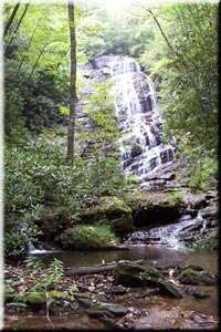
Horsetrough Falls are located on one of the flanks of Horsetrough Mountain in Union County, Georgia. This 70-foot (21 m) waterfall is located on a creek that is part of the headwaters of the Chattahoochee River and is in the Mark Trail Wilderness. There is an observation platform at the falls which can be reached by the 0.4-mile (0.64 km) Horsetrough Falls Trail. The trail begins at the nearby Upper Chattahoochee Campground camping area, which is maintained and operated by the Chattooga Ranger District of the Chattahoochee National Forest. The Eastern Continental Divide follows the main ridge line of Horsetrough Mountain and the water passes over Horsetrough Falls to begin a 500-mile (800 km) journey to the Gulf of Mexico via the Chattahoochee River.