Horná Štubňa
| Horná Štubňa | |
| Village | |
 Horná Štubňa | |
| Country | Slovakia |
|---|---|
| Region | Žilina |
| District | Turčianske Teplice |
| Elevation | 627 m (2,057 ft) |
| Coordinates | 48°49′30″N 18°53′03″E / 48.82493°N 18.88423°ECoordinates: 48°49′30″N 18°53′03″E / 48.82493°N 18.88423°E |
| Area | 31.388 km2 (12.12 sq mi) |
| Population | 1,621 (2005-12-31) |
| Density | 52/km2 (135/sq mi) |
| First mentioned | 1390 |
| Postal code | 038 46 |
| Area code | +421-43 |
| Car plate | TR |
  Location of Horná Štubňa in Slovakia | |
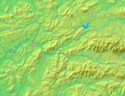  Location of Horná Štubňa in the Žilina Region | |
| Statistics: MOŠ/MIS | |
| Website: www.hornastubna.sk | |
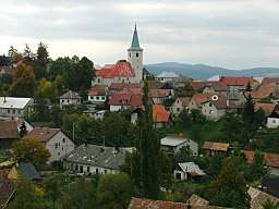
Horná Štubňa is a village and municipality in Turčianske Teplice District in the Žilina Region of northern central Slovakia.
History
In historical records the village was first mentioned in 1390.
Geography
The municipality lies at an altitude of 627 metres and covers an area of 31.388 km². It has a population of about 1,610 people.
Famous people
- Emília Vášáryová, actress
| Wikimedia Commons has media related to Horná Štubňa. |
Genealogical resources
The records for genealogical research are available at the state archive "Statny Archiv in Bytca, Slovakia"
- Roman Catholic church records (births/marriages/deaths): 1737-1919 (parish A)
- Lutheran church records (births/marriages/deaths): 1820-1923 (parish B)
See also
External links
Municipalities of Turčianske Teplice District | ||
|---|---|---|
This article is issued from
Wikipedia.
The text is licensed under Creative Commons - Attribution - Sharealike.
Additional terms may apply for the media files.