Hopton Heath railway station
| Hopton Heath | |
|---|---|
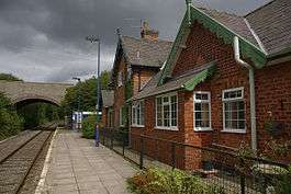 The original station building and present-day platform, looking north. | |
| Location | |
| Place | Hopton Heath |
| Local authority | Shropshire Council |
| Grid reference | SO380774 |
| Operations | |
| Station code | HPT |
| Managed by | Arriva Trains Wales |
| Number of platforms | 1 |
| DfT category | F2 |
|
Live arrivals/departures, station information and onward connections from National Rail Enquiries | |
| Annual rail passenger usage* | |
| 2012/13 |
|
| 2013/14 |
|
| 2014/15 |
|
| 2015/16 |
|
| 2016/17 |
|
| History | |
| Key dates | Opened 1861 |
| National Rail – UK railway stations | |
| * Annual estimated passenger usage based on sales of tickets in stated financial year(s) which end or originate at Hopton Heath from Office of Rail and Road statistics. Methodology may vary year on year. | |
|
| |
Hopton Heath railway station is a railway station (now more akin to a halt) in Hopton Heath, a hamlet in Shropshire, England (which is alternatively spelled as a single word "Hoptonheath"). It lies on the Heart of Wales Line, 25 1⁄2 miles (41.0 km) south west of Shrewsbury.
The station is situated in a very rural area; the nearest sizeable settlement is Hopton Castle and further afield are the larger villages of Clungunford and Leintwardine (the latter in Herefordshire). The station was for a number of years the least used National Rail station in Shropshire, however passenger numbers have recently increased and now Broome is the county's least used station.
The station and line were constructed by the Knighton Railway and opened in 1861. Further construction and route openings in 1865 and 1868 subsequently put the station on a through route between Shrewsbury and Swansea.
The railway station is located below street level, to the south of the B4385 road bridge. The original station building is now private housing.[1] Originally there were two tracks running through, but one has been lifted with the "singling" of the line in general back in the early 1960s. In addition to the main building, the station has retained its stone weighbridge hut next to the entrance.
The station has two platforms: the original (but now disused) Shrewsbury-bound platform extends entirely to the south of the bridge; the remaining passenger platform (originally for Swansea-bound trains, but now used for all trains) extends under the bridge, though at present only the part to the south is usually used by passengers.[2]
A wooden waiting shelter is located on the platform, along with CIS display, customer help point and timetable poster board are provided to offer train running information.[3]
Access to the platform is via steps from the road bridge or alternatively via a level footpath (which cycles are also allowed to use) which runs south from the station to the "Ashlea Pools" holiday park entrance.
Services
There are four southbound and five northbound trains a day from Monday to Friday, four each way on Saturdays and two on Sundays. This is a request stop, whereby passengers have to signal to the driver to board or alight from the train. A normal weekday service operates on most Bank holidays.[4]
All trains serving the station are operated by Arriva Trains Wales.
Bus service
A local bus service (the 740, run by Arriva) calls near the station, which travels between Ludlow and Knighton and calls at the nearby villages of Bedstone, Clungunford and Leintwardine. Currently 3 buses per day call at Hopton Heath in each direction.[5]
See also
References
- ↑ Hopton Heath railway station (2013) Thompson, Nigel Geograph.org.uk; Retrieved 26 July 2017
- ↑ Waiting room at Hopton Heath station (2014) Winder, John Geograph.org.uk ; Retrieved 26 July 2017
- ↑ Hopton Heath station facilities National Rail Enquiries
- ↑ Table 129 National Rail timetable, May 2017
- ↑ Arriva 738, 740
Further reading
External links
| Wikimedia Commons has media related to Hopton Heath railway station. |
- Train times and station information for Hopton Heath railway station from National Rail
| Preceding station | Following station | |||
|---|---|---|---|---|
| Bucknell | Arriva Trains Wales Heart of Wales Line |
Broome | ||