Hongdo
| Hongdo | |
|---|---|
| Korean transcription(s) | |
| • Hangul | 홍도 |
| • Hanja | 紅島 |
| • Revised Romanization | Hongdo |
| • McCune–Reischauer | Hongto |
 | |
| Country | South Korea |
| Area[1] | |
| • Total | 6.47 km2 (2.50 sq mi) |
| Population (2001)[2] | |
| • Total | 710 |
| • Density | 110/km2 (280/sq mi) |
| Wikimedia Commons has media related to Hongdo. |
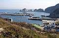
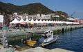
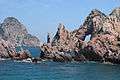
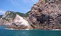
Hongdo is an island in the Yellow Sea located 115 km from the southwest coast of Mokpo port, Jeollanam-do, South Korea. It covers an area of 6.47 km² and consists of steep mountain range, the highest peaks of which are Gitdaebong (깃대봉 378 m) and Yangsanbong (양산봉 231 m).[1] It is within the administrative boundaries of Sinan County, Jeollanam-do, South Korea. The island's 6.47 km² are home to about 710 people.[2]
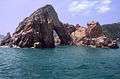
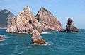
On Hongdo, meaning "Red Island" due to the red coloring found on many of the rocky outcroppings, there are about 270 varieties of evergreens and 170 species of animals. The government wished to preserve the natural state of the island so Hongdo was designated as a Natural Preserve Area in 1965, and became part of Dadohae Marine National Park in 1981. Because the entire island of Hongdo is declared a Natural Monument, no one is allowed to enter areas other than the villages and designated tourist areas.[3]
Gallery

See also
References
- 1 2 홍도 紅島 (in Korean). Doosan Encyber. Retrieved 2008-05-12.
- 1 2 "Hongdo". Sinan County official website. Retrieved 2008-05-12.
- ↑ "Visit Korea - Hongdo". Retrieved 2012-02-21.
External links
| Wikivoyage has a travel guide for Hongdo. |
- Hongdo at the official site of Sinan County government
Coordinates: 34°41′35″N 125°11′50″E / 34.69306°N 125.19722°E