Honey Lane Market
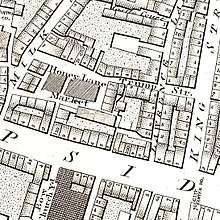

Honey Lane Market was an historic market near Cheapside in the City of London.
It was built at the south end of Milk Street on the site of the parish church of St Mary Magdalen after that church was destroyed in the Great Fire of London in 1666 and not rebuilt. The market at one time had 105 butchers' stalls.[2] Edward Hatton noted in 1708 that the market was known for its meat, fish, and poultry.[3]
By 1835 the market had closed and the City of London School was built on the market site on the corner with Russia Row.[4] It was paid for with money bequethed for the purpose by John Carpenter, city clerk in the reign of King Henry V.[5] It grew so rapidly that in 1883 it moved to the Victoria Embankment.[6]
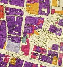
Honey Lane was completely destroyed and the surrounding area seriously damaged by German bombing on 29 December 1940.[5]
The current Honey Lane is approximately 100 yards east of the old one and connects Cheapside and Trump Street.
See also
References
- ↑ The meticulously hand-coloured bomb damage maps of London – in pictures. The Guardian, 2 September 2015. Retrieved 4 February 2018.
- ↑ "Honey Lane Market" in Christopher Hibbert; Ben Weinreb; John Keay; Julia Keay. (2008). The London Encyclopaedia (3rd ed.). London: Pan Macmillan. p. 413. ISBN 978-0-230-73878-2.
- ↑ Milk Street. British History Online. Retrieved 6 February 2018.
- ↑ "Honey Lane Market" in Hibbert et al, The London Encyclopaedia, p. 413.
- 1 2 "Milk Street EC2" in Al Smith (1970) Dictionary of City of London Street Names. Newton Abbot: David & Charles. p. 139. ISBN 0715348809
- ↑ "City of London School" in Hibbert et al, The London Encyclopaedia, pp. 187-188.
External links
![]()