Honduras–Nicaragua border
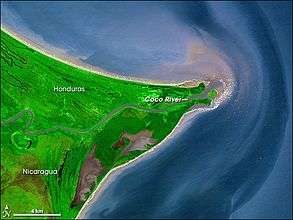
The Honduras–Nicaragua border is the 352 km long international boundary between Honduras and Nicaragua, linking the Gulf of Fonseca (Pacific Ocean) to the Caribbean Sea coast, which separates southern Honduras from northern Nicaragua. The Coco River forms part of the east border. It passes between the following departments, from west to east:
- Honduras - Choluteca, Colón, Olancho, Gracias a Dios.
- Nicaragua - Chinandega, Madriz, Nueva Segovia, Jinotega and North Caribbean Coast Autonomous Region.
Honduras and Nicaragua were part of, respectively, Central American Federation and the United Provinces of Central America, between 1823 and 1838, when the unions of countries fell apart and both nations gained their independence and define the border.
In 1937, the issuance of a stamp from Nicaragua with a sticker on part of Honduran territory indicating "territory in dispute" almost caused a war between the two countries.[1] The territory had been claimed by Nicaragua, but Honduras thought the matter closed in 1906 when an arbitration by King Alfonso XIII of Spain gave it the area.
The roots of the problem of chaotic genesis of this border lie in the way of the independence process in 1821 as a federal republic.