Hohenpolding
| Hohenpolding | ||
|---|---|---|
| ||
 Hohenpolding Location of Hohenpolding within Erding district 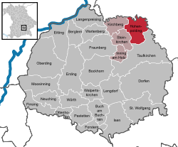 | ||
| Coordinates: 48°23′4″N 12°7′55″E / 48.38444°N 12.13194°ECoordinates: 48°23′4″N 12°7′55″E / 48.38444°N 12.13194°E | ||
| Country | Germany | |
| State | Bavaria | |
| Admin. region | Oberbayern | |
| District | Erding | |
| Municipal assoc. | Steinkirchen | |
| Government | ||
| • Mayor | Heribert Niedermaier | |
| Area | ||
| • Total | 27.42 km2 (10.59 sq mi) | |
| Elevation | 488 m (1,601 ft) | |
| Population (2017-12-31)[1] | ||
| • Total | 1,579 | |
| • Density | 58/km2 (150/sq mi) | |
| Time zone | CET/CEST (UTC+1/+2) | |
| Postal codes | 84432 | |
| Dialling codes | 08084 | |
| Vehicle registration | ED | |
| Website | www.hohenpolding.de | |

Hohenpolding is a municipality in the district of Erding in Bavaria in Germany.
Towns and municipalities in Erding (district) | ||
|---|---|---|
References
- ↑ "Fortschreibung des Bevölkerungsstandes". Bayerisches Landesamt für Statistik und Datenverarbeitung (in German). September 2018.
This article is issued from
Wikipedia.
The text is licensed under Creative Commons - Attribution - Sharealike.
Additional terms may apply for the media files.