Hohe Dock
| Hohe Dock | |
|---|---|
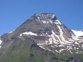 Hohe Dock from the Großglockner High Alpine Road | |
| Highest point | |
| Elevation | 3348 m AA |
| Isolation | 0.6 kilometres (0.37 mi) |
| Coordinates | 47°07′51″N 12°44′27″E / 47.13083°N 12.74083°ECoordinates: 47°07′51″N 12°44′27″E / 47.13083°N 12.74083°E |
| Geography | |
 Hohe Dock Austria | |
| Location | Salzburg, Austria |
| Parent range | Glockner Group / High Tauern |
| Climbing | |
| First ascent | ca. 1842 - 1845 G. Mayer (Badhans) during a hunt[1] |
The Hohe Dock lies in the Austrian federal state of Salzburg and, at 3,348 metres, is one of the highest peaks in the Glockner Group. The mountain, with its striking trapezoidal shape, dominates the orographically left-hand side of the valley of the Fuscher Ache and the panorama above the northern ramp of the Großglockner High Alpine Road.
Its secondary peak, the southeastern summit, reaches a height of 3,268 m above sea level (AA).
Climbing route
The start point is the head of the valley at Fusch an der Großglocknerstraße (Ferleiten). The summit is ascended via the Schwarzenberg Hut (2,267 m) along a signed, high alpine path.
References
- ↑ Willi End, Hubert Peterka: Alpenvereinsführer Glockner- und Granatspitzgruppe, Bergverlag Rudolf Rother, München 1990. ISBN 3-7633-1258-7
External links
- Climbing the Hohe Dock - (Czech / English)
Gallery
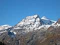 The Hohe Dock from the northeast
This article is issued from
Wikipedia.
The text is licensed under Creative Commons - Attribution - Sharealike.
Additional terms may apply for the media files.