Hochstadl
| Hochstadl | |
|---|---|
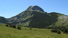 The Hochstadl seen from northeast. | |
| Highest point | |
| Elevation | 1,919 m (6,296 ft) [1] |
| Prominence | 1,072 m (3,517 ft) [2] |
| Coordinates | 47°41′11″N 15°04′31″E / 47.68639°N 15.07528°ECoordinates: 47°41′11″N 15°04′31″E / 47.68639°N 15.07528°E |
| Geography | |
| Parent range | Northern Lower Austria Alps |
| Climbing | |
| Easiest route | through the Kräuterinhütte |

The Hochstadl is a mountain of the Ybbstal Alps located in Styria, Austria, belonging to the Kräuterin karst massif. It is the highest summit of the Northern Lower Austria Alps.
Geography
Administratively the mountain belongs to the Austrian state of Styria.
Access to the summit
The suggested route for the mountain starts from Dürradmer and reaches the top through the Kräuterinhütte (Kräuterin mountain hut) at 1,394 m.[3]
References
- ↑ Die Kräuterin (Hochstadl) 1919 m, article on ergkraxler.heimat.eu (accessed in May 2012)
- ↑ "Hochstadl - Peakbagger". "peakbagger.com. Retrieved 23 February 2016.
- ↑ Kräuterinhütte (1394 m), article on www.tourensuche.eu (accessed in May 2012)
External links
- Article in German on bergkraxler.heimat.eu
This article is issued from
Wikipedia.
The text is licensed under Creative Commons - Attribution - Sharealike.
Additional terms may apply for the media files.