Plattberg
| Plattberg | |
|---|---|
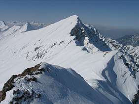 The Hochschrutte from the Pfuitjöchl in winter | |
| Highest point | |
| Elevation | 2,247 m (AA) (7,372 ft) |
| Prominence | 2,247-2,045 m ↓ Hebertaljoch |
| Isolation | 2.7 km → Upsspitze |
| Coordinates | 47°26′42″N 10°50′31″E / 47.445°N 10.84194°ECoordinates: 47°26′42″N 10°50′31″E / 47.445°N 10.84194°E |
| Geography | |
| Parent range | Ammergau Alps |
| Geology | |
| Age of rock | Upper Carnian - Rhaetian |
| Type of rock | main dolomite, plattenkalk, Kössen Formation |

The Plattberg (also Blattberg) is a mountain in the southern chain of the Ammergau Alps. Its highest point is also called the Hochschrutte and reaches a height of 2,247 m (AA) The Plattberg lies north of Lähn and can be climbed from Lähn (railway station on the Außerfern Railway) or, on a more strenuous and trackless route from the lake of Plansee via the Wiesjoch col. The ascent of the mountain can be done as part of a ridge walk from or to the Daniel. The nearby peak of Großes fuitjöchl (2,196 m) is also a popular climb in winter for skiers or snowshoers.
Literature and external links
| Wikimedia Commons has media related to Plattberg. |
This article is issued from
Wikipedia.
The text is licensed under Creative Commons - Attribution - Sharealike.
Additional terms may apply for the media files.